You are here: Home > Network List > CN - Canadian National Seismograph Network Stations List
> Station INK INUVIK, NT > Earthquake Result Viewer
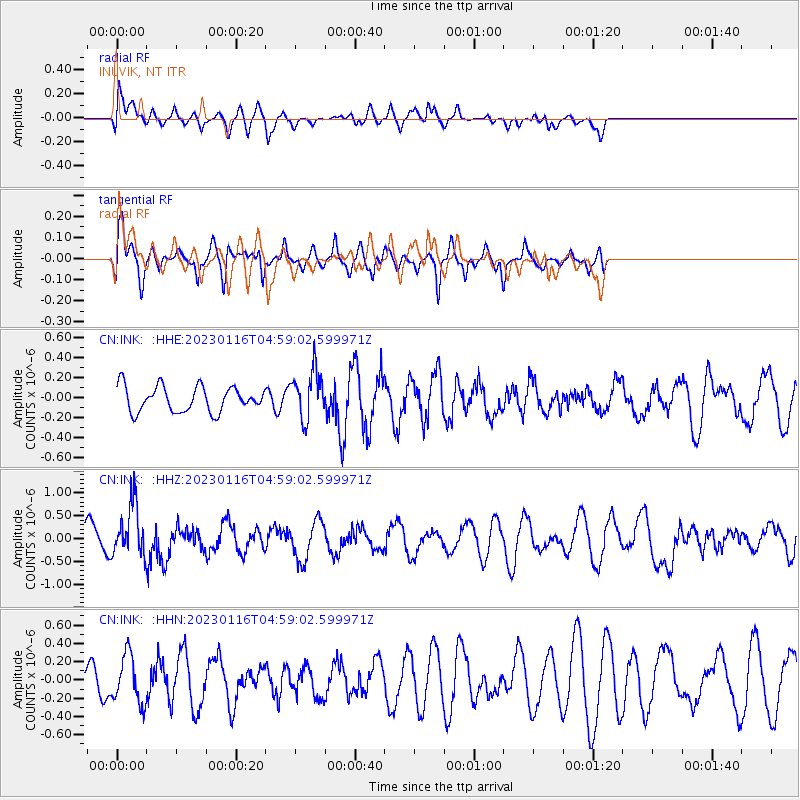
INK INUVIK, NT - Earthquake Result Viewer
*The percent match for this event was below the threshold and hence no stack was calculated.
| Earthquake location: |
Bonin Islands, Japan Region |
| Earthquake latitude/longitude: |
29.0/139.4 |
| Earthquake time(UTC): |
2023/01/16 (016) 04:49:52 GMT |
| Earthquake Depth: |
405 km |
| Earthquake Magnitude: |
6.3 mww |
| Earthquake Catalog/Contributor: |
NEIC PDE/us |
|
| Network: |
CN Canadian National Seismograph Network |
| Station: |
INK INUVIK, NT |
| Lat/Lon: |
68.31 N/133.53 W |
| Elevation: |
44 m |
|
| Distance: |
62.4 deg |
| Az: |
24.782 deg |
| Baz: |
278.981 deg |
| Ray Param: |
$rayparam |
*The percent match for this event was below the threshold and hence was not used in the summary stack. |
|
| Radial Match: |
59.346478 % |
| Radial Bump: |
400 |
| Transverse Match: |
53.86909 % |
| Transverse Bump: |
400 |
| SOD ConfigId: |
29823551 |
| Insert Time: |
2023-01-30 05:04:43.220 +0000 |
| GWidth: |
2.5 |
| Max Bumps: |
400 |
| Tol: |
0.001 |
|
Signal To Noise
| Channel | StoN | STA | LTA |
| CN:INK: :HHZ:20230116T04:59:02.599971Z | 1.9048901 | 5.6382606E-7 | 2.9598877E-7 |
| CN:INK: :HHN:20230116T04:59:02.599971Z | 1.2410913 | 2.6308157E-7 | 2.1197602E-7 |
| CN:INK: :HHE:20230116T04:59:02.599971Z | 1.89114 | 2.373875E-7 | 1.2552614E-7 |
| Arrivals |
| Ps | |
| PpPs | |
| PsPs/PpSs | |


