You are here: Home > Network List > TA - USArray Transportable Network (new EarthScope stations) Stations List
> Station Q30A Quinter, KS, USA > Earthquake Result Viewer
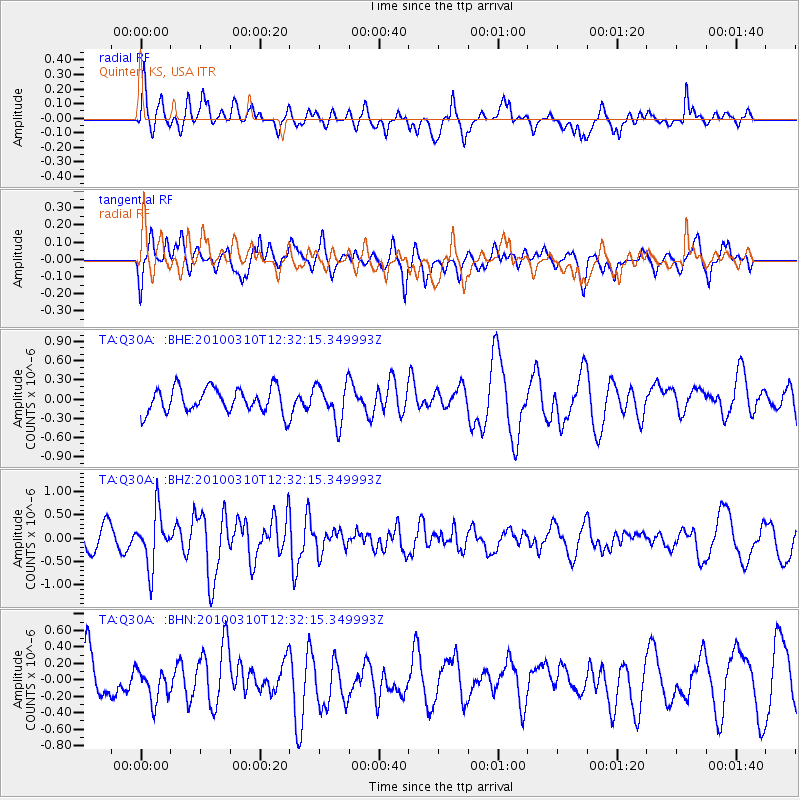
Q30A Quinter, KS, USA - Earthquake Result Viewer
*The percent match for this event was below the threshold and hence no stack was calculated.
| Earthquake location: |
Off Coast Of Central Chile |
| Earthquake latitude/longitude: |
-33.6/-72.3 |
| Earthquake time(UTC): |
2010/03/10 (069) 12:20:58 GMT |
| Earthquake Depth: |
35 km |
| Earthquake Magnitude: |
5.5 MB, 5.5 MS |
| Earthquake Catalog/Contributor: |
WHDF/NEIC |
|
| Network: |
TA USArray Transportable Network (new EarthScope stations) |
| Station: |
Q30A Quinter, KS, USA |
| Lat/Lon: |
38.98 N/100.22 W |
| Elevation: |
797 m |
|
| Distance: |
76.7 deg |
| Az: |
337.97 deg |
| Baz: |
156.308 deg |
| Ray Param: |
$rayparam |
*The percent match for this event was below the threshold and hence was not used in the summary stack. |
|
| Radial Match: |
63.348602 % |
| Radial Bump: |
392 |
| Transverse Match: |
43.437572 % |
| Transverse Bump: |
400 |
| SOD ConfigId: |
299721 |
| Insert Time: |
2010-04-26 21:31:01.080 +0000 |
| GWidth: |
2.5 |
| Max Bumps: |
400 |
| Tol: |
0.001 |
|
Signal To Noise
| Channel | StoN | STA | LTA |
| TA:Q30A: :BHZ:20100310T12:32:15.349993Z | 3.2036111 | 5.698014E-7 | 1.7786222E-7 |
| TA:Q30A: :BHN:20100310T12:32:15.349993Z | 0.5462809 | 2.0609629E-7 | 3.7727162E-7 |
| TA:Q30A: :BHE:20100310T12:32:15.349993Z | 1.5492572 | 2.9844514E-7 | 1.9263759E-7 |
| Arrivals |
| Ps | |
| PpPs | |
| PsPs/PpSs | |


