You are here: Home > Network List > XA95 - Missouri to Massachusetts Transect Stations List
> Station MM18 Tyson, Missiouri > Earthquake Result Viewer
MM18 Tyson, Missiouri - Earthquake Result Viewer
| Earthquake location: |
Greece |
| Earthquake latitude/longitude: |
38.4/22.3 |
| Earthquake time(UTC): |
1995/06/15 (166) 00:15:48 GMT |
| Earthquake Depth: |
14 km |
| Earthquake Magnitude: |
6.0 MB, 6.5 MS, 6.5 UNKNOWN, 5.7 ML |
| Earthquake Catalog/Contributor: |
WHDF/NEIC |
|
| Network: |
XA Missouri to Massachusetts Transect |
| Station: |
MM18 Tyson, Missiouri |
| Lat/Lon: |
38.53 N/90.57 W |
| Elevation: |
186 m |
|
| Distance: |
81.7 deg |
| Az: |
313.07 deg |
| Baz: |
47.038 deg |
| Ray Param: |
0.047403656 |
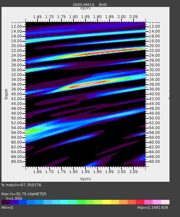
| Estimated Moho Depth: |
35.75 km |
| Estimated Crust Vp/Vs: |
1.86 |
| Assumed Crust Vp: |
6.498 km/s |
| Estimated Crust Vs: |
3.503 km/s |
| Estimated Crust Poisson's Ratio: |
0.30 |
|
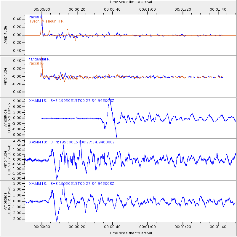
| Radial Match: |
97.358376 % |
| Radial Bump: |
335 |
| Transverse Match: |
88.90174 % |
| Transverse Bump: |
400 |
| SOD ConfigId: |
6273 |
| Insert Time: |
2010-02-26 17:57:11.627 +0000 |
| GWidth: |
2.5 |
| Max Bumps: |
400 |
| Tol: |
0.001 |
|
Signal To Noise
| Channel | StoN | STA | LTA |
| XA:MM18: :BHN:19950615T00:27:34.946008Z | 1.6339113 | 1.7919088E-7 | 1.096699E-7 |
| XA:MM18: :BHE:19950615T00:27:34.946008Z | 2.9815192 | 2.9444286E-7 | 9.8755976E-8 |
| XA:MM18: :BHZ:19950615T00:27:34.946008Z | 5.5908127 | 6.8792554E-7 | 1.2304571E-7 |
| Arrivals |
| Ps | 4.8 SECOND |
| PpPs | 15 SECOND |
| PsPs/PpSs | 20 SECOND |


