You are here: Home > Network List > IU - Global Seismograph Network (GSN - IRIS/USGS) Stations List
> Station PMG Port Moresby, New Guinea > Earthquake Result Viewer
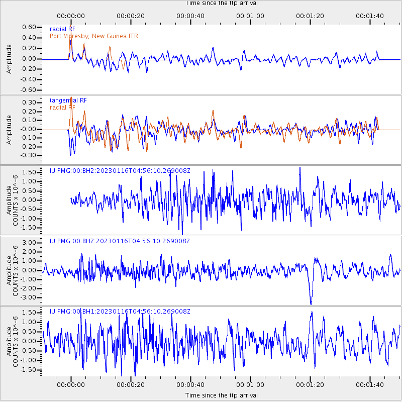
PMG Port Moresby, New Guinea - Earthquake Result Viewer
*The percent match for this event was below the threshold and hence no stack was calculated.
| Earthquake location: |
Bonin Islands, Japan Region |
| Earthquake latitude/longitude: |
29.0/139.4 |
| Earthquake time(UTC): |
2023/01/16 (016) 04:49:52 GMT |
| Earthquake Depth: |
405 km |
| Earthquake Magnitude: |
6.3 mww |
| Earthquake Catalog/Contributor: |
NEIC PDE/us |
|
| Network: |
IU Global Seismograph Network (GSN - IRIS/USGS) |
| Station: |
PMG Port Moresby, New Guinea |
| Lat/Lon: |
9.40 S/147.16 E |
| Elevation: |
90 m |
|
| Distance: |
38.9 deg |
| Az: |
167.69 deg |
| Baz: |
349.088 deg |
| Ray Param: |
$rayparam |
*The percent match for this event was below the threshold and hence was not used in the summary stack. |
|
| Radial Match: |
48.99281 % |
| Radial Bump: |
400 |
| Transverse Match: |
47.134144 % |
| Transverse Bump: |
400 |
| SOD ConfigId: |
29823551 |
| Insert Time: |
2023-01-30 05:08:58.043 +0000 |
| GWidth: |
2.5 |
| Max Bumps: |
400 |
| Tol: |
0.001 |
|
Signal To Noise
| Channel | StoN | STA | LTA |
| IU:PMG:00:BHZ:20230116T04:56:10.269008Z | 2.1892726 | 6.5249753E-7 | 2.9804306E-7 |
| IU:PMG:00:BH1:20230116T04:56:10.269008Z | 1.8585805 | 6.606256E-7 | 3.554463E-7 |
| IU:PMG:00:BH2:20230116T04:56:10.269008Z | 2.041836 | 7.398725E-7 | 3.6235647E-7 |
| Arrivals |
| Ps | |
| PpPs | |
| PsPs/PpSs | |


