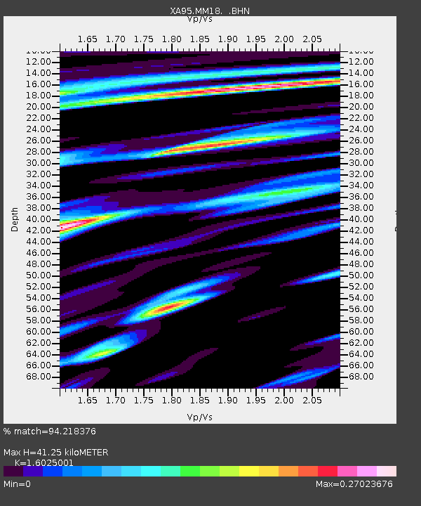
MM18 Tyson, Missiouri - Earthquake Result Viewer
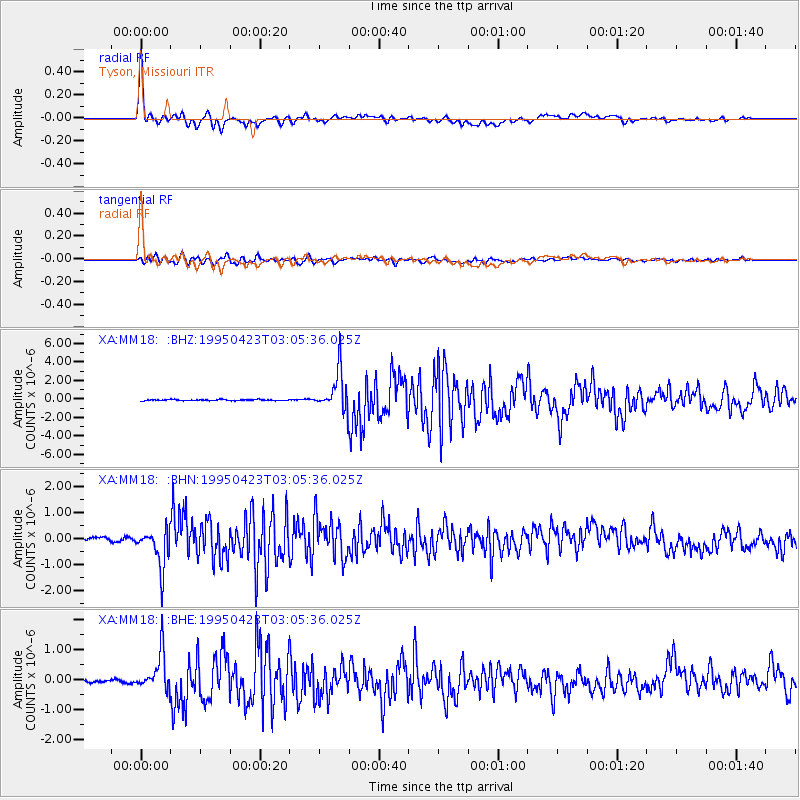
Earthquake location: Rat Islands, Aleutian Islands
Earthquake latitude/longitude: 51.3/179.7
Earthquake time(UTC): 1995/04/23 (113) 02:55:54 GMT
Earthquake Depth: 16 km
Earthquake Magnitude: 6.1 MB, 6.4 MS, 6.5 UNKNOWN, 6.7 ML
Earthquake Catalog/Contributor: WHDF/NEIC
Network: XA Missouri to Massachusetts Transect
Station: MM18 Tyson, Missiouri
Lat/Lon: 38.53 N/90.57 W
Elevation: 186 m
Distance: 61.0 deg
Az: 63.79 deg
Baz: 314.151 deg
Ray Param: 0.06117937
Estimated Moho Depth: 41.25 km
Estimated Crust Vp/Vs: 1.60
Assumed Crust Vp: 6.498 km/s
Estimated Crust Vs: 4.055 km/s
Estimated Crust Poisson's Ratio: 0.18
Radial Match: 94.218376 %
Radial Bump: 400
Transverse Match: 84.86374 %
Transverse Bump: 400
SOD ConfigId: 6273
Insert Time: 2010-02-26 17:57:14.606 +0000
GWidth: 2.5
Max Bumps: 400
Tol: 0.001

Signal To Noise

ChannelStoNSTALTA
XA:MM18: :BHN:19950423T03:05:36.025Z5.97769457.2296956E-71.2094453E-7
XA:MM18: :BHE:19950423T03:05:36.025Z9.6135166.219241E-76.469268E-8
XA:MM18: :BHZ:19950423T03:05:36.025Z35.0380862.1159137E-66.038896E-8
Arrivals
Ps4.0 SECOND
PpPs16 SECOND
PsPs/PpSs20 SECOND