You are here: Home > Network List > TA - USArray Transportable Network (new EarthScope stations) Stations List
> Station R32A Long Quarter, Great Bend, KS, USA > Earthquake Result Viewer
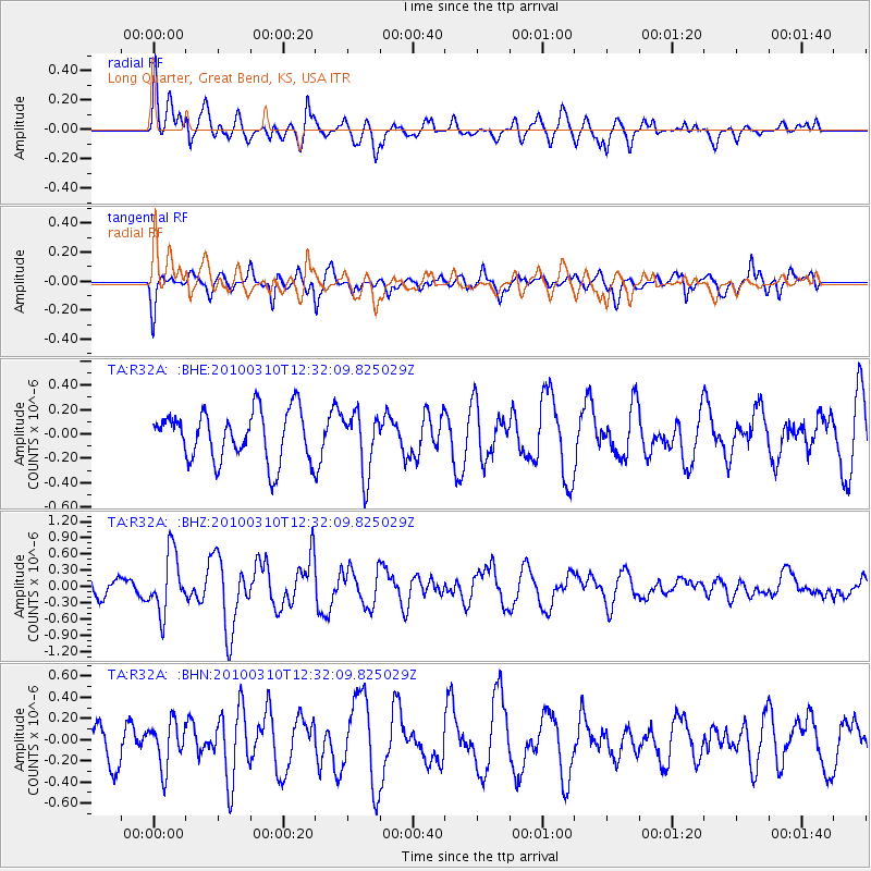
R32A Long Quarter, Great Bend, KS, USA - Earthquake Result Viewer
*The percent match for this event was below the threshold and hence no stack was calculated.
| Earthquake location: |
Off Coast Of Central Chile |
| Earthquake latitude/longitude: |
-33.6/-72.3 |
| Earthquake time(UTC): |
2010/03/10 (069) 12:20:58 GMT |
| Earthquake Depth: |
35 km |
| Earthquake Magnitude: |
5.5 MB, 5.5 MS |
| Earthquake Catalog/Contributor: |
WHDF/NEIC |
|
| Network: |
TA USArray Transportable Network (new EarthScope stations) |
| Station: |
R32A Long Quarter, Great Bend, KS, USA |
| Lat/Lon: |
38.42 N/98.71 W |
| Elevation: |
573 m |
|
| Distance: |
75.7 deg |
| Az: |
338.865 deg |
| Baz: |
157.462 deg |
| Ray Param: |
$rayparam |
*The percent match for this event was below the threshold and hence was not used in the summary stack. |
|
| Radial Match: |
56.60582 % |
| Radial Bump: |
400 |
| Transverse Match: |
63.991096 % |
| Transverse Bump: |
400 |
| SOD ConfigId: |
299721 |
| Insert Time: |
2010-04-26 21:35:08.328 +0000 |
| GWidth: |
2.5 |
| Max Bumps: |
400 |
| Tol: |
0.001 |
|
Signal To Noise
| Channel | StoN | STA | LTA |
| TA:R32A: :BHZ:20100310T12:32:09.825029Z | 2.3460882 | 5.516818E-7 | 2.3514964E-7 |
| TA:R32A: :BHN:20100310T12:32:09.825029Z | 0.7385317 | 2.1374234E-7 | 2.8941523E-7 |
| TA:R32A: :BHE:20100310T12:32:09.825029Z | 1.2160233 | 2.4822214E-7 | 2.0412612E-7 |
| Arrivals |
| Ps | |
| PpPs | |
| PsPs/PpSs | |


