You are here: Home > Network List > TA - USArray Transportable Network (new EarthScope stations) Stations List
> Station V33A Lossen Ranch, Watonga, OK, USA > Earthquake Result Viewer
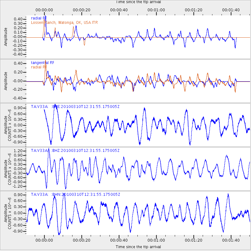
V33A Lossen Ranch, Watonga, OK, USA - Earthquake Result Viewer
*The percent match for this event was below the threshold and hence no stack was calculated.
| Earthquake location: |
Off Coast Of Central Chile |
| Earthquake latitude/longitude: |
-33.6/-72.3 |
| Earthquake time(UTC): |
2010/03/10 (069) 12:20:58 GMT |
| Earthquake Depth: |
35 km |
| Earthquake Magnitude: |
5.5 MB, 5.5 MS |
| Earthquake Catalog/Contributor: |
WHDF/NEIC |
|
| Network: |
TA USArray Transportable Network (new EarthScope stations) |
| Station: |
V33A Lossen Ranch, Watonga, OK, USA |
| Lat/Lon: |
35.82 N/98.29 W |
| Elevation: |
420 m |
|
| Distance: |
73.2 deg |
| Az: |
338.159 deg |
| Baz: |
157.528 deg |
| Ray Param: |
$rayparam |
*The percent match for this event was below the threshold and hence was not used in the summary stack. |
|
| Radial Match: |
55.24016 % |
| Radial Bump: |
400 |
| Transverse Match: |
53.980515 % |
| Transverse Bump: |
400 |
| SOD ConfigId: |
299721 |
| Insert Time: |
2010-04-26 21:35:31.621 +0000 |
| GWidth: |
2.5 |
| Max Bumps: |
400 |
| Tol: |
0.001 |
|
Signal To Noise
| Channel | StoN | STA | LTA |
| TA:V33A: :BHZ:20100310T12:31:55.175005Z | 1.9706949 | 6.855261E-7 | 3.4786012E-7 |
| TA:V33A: :BHN:20100310T12:31:55.175005Z | 1.5019674 | 4.2498138E-7 | 2.829498E-7 |
| TA:V33A: :BHE:20100310T12:31:55.175005Z | 0.39736724 | 2.0673306E-7 | 5.2025695E-7 |
| Arrivals |
| Ps | |
| PpPs | |
| PsPs/PpSs | |


