You are here: Home > Network List > AU - Australian Seismological Centre Stations List
> Station ARMA Armidale, New South Wales > Earthquake Result Viewer
ARMA Armidale, New South Wales - Earthquake Result Viewer
| Earthquake location: |
Minahassa Peninsula, Sulawesi |
| Earthquake latitude/longitude: |
-0.0/123.2 |
| Earthquake time(UTC): |
2023/01/18 (018) 00:34:43 GMT |
| Earthquake Depth: |
147 km |
| Earthquake Magnitude: |
6.1 mww |
| Earthquake Catalog/Contributor: |
NEIC PDE/us |
|
| Network: |
AU Australian Seismological Centre |
| Station: |
ARMA Armidale, New South Wales |
| Lat/Lon: |
30.42 S/151.63 E |
| Elevation: |
1112 m |
|
| Distance: |
40.5 deg |
| Az: |
140.721 deg |
| Baz: |
312.871 deg |
| Ray Param: |
0.073796354 |
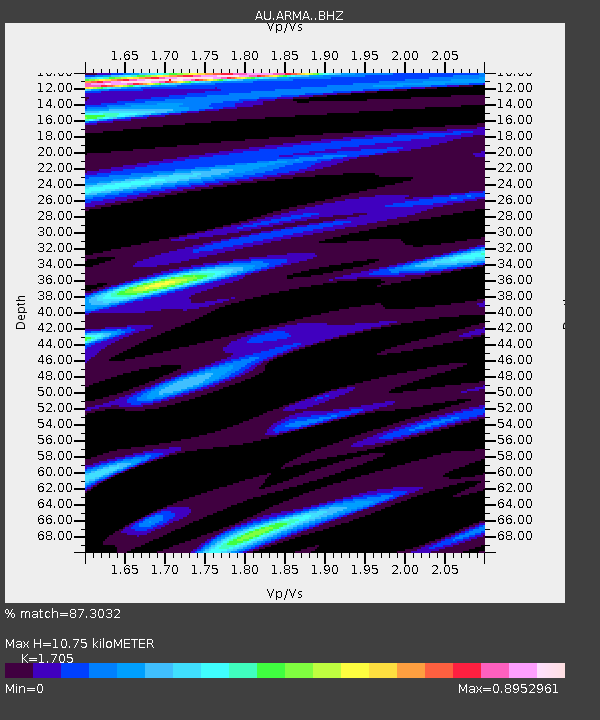
| Estimated Moho Depth: |
10.75 km |
| Estimated Crust Vp/Vs: |
1.71 |
| Assumed Crust Vp: |
6.577 km/s |
| Estimated Crust Vs: |
3.857 km/s |
| Estimated Crust Poisson's Ratio: |
0.24 |
|
| Radial Match: |
87.3032 % |
| Radial Bump: |
329 |
| Transverse Match: |
63.61422 % |
| Transverse Bump: |
400 |
| SOD ConfigId: |
29823551 |
| Insert Time: |
2023-02-01 00:39:37.018 +0000 |
| GWidth: |
2.5 |
| Max Bumps: |
400 |
| Tol: |
0.001 |
|

Signal To Noise
| Channel | StoN | STA | LTA |
| AU:ARMA: :BHZ:20230118T00:41:37.969004Z | 6.50792 | 1.3965546E-6 | 2.145931E-7 |
| AU:ARMA: :BHN:20230118T00:41:37.969004Z | 3.4164941 | 6.707076E-7 | 1.9631459E-7 |
| AU:ARMA: :BHE:20230118T00:41:37.969004Z | 3.6266017 | 8.1046545E-7 | 2.2347794E-7 |
| Arrivals |
| Ps | 1.2 SECOND |
| PpPs | 4.1 SECOND |
| PsPs/PpSs | 5.3 SECOND |


