You are here: Home > Network List > XA95 - Missouri to Massachusetts Transect Stations List
> Station MM18 Tyson, Missiouri > Earthquake Result Viewer
MM18 Tyson, Missiouri - Earthquake Result Viewer
| Earthquake location: |
Greece |
| Earthquake latitude/longitude: |
40.1/21.7 |
| Earthquake time(UTC): |
1995/05/13 (133) 08:47:12 GMT |
| Earthquake Depth: |
13 km |
| Earthquake Magnitude: |
6.2 MB, 6.5 MS, 6.6 UNKNOWN, 6.5 MD |
| Earthquake Catalog/Contributor: |
WHDF/NEIC |
|
| Network: |
XA Missouri to Massachusetts Transect |
| Station: |
MM18 Tyson, Missiouri |
| Lat/Lon: |
38.53 N/90.57 W |
| Elevation: |
186 m |
|
| Distance: |
80.2 deg |
| Az: |
312.547 deg |
| Baz: |
46.057 deg |
| Ray Param: |
0.048452858 |
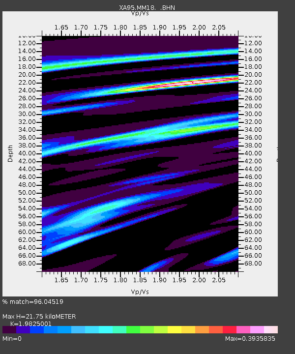
| Estimated Moho Depth: |
21.75 km |
| Estimated Crust Vp/Vs: |
1.98 |
| Assumed Crust Vp: |
6.498 km/s |
| Estimated Crust Vs: |
3.277 km/s |
| Estimated Crust Poisson's Ratio: |
0.33 |
|
| Radial Match: |
96.04519 % |
| Radial Bump: |
335 |
| Transverse Match: |
83.85939 % |
| Transverse Bump: |
400 |
| SOD ConfigId: |
6273 |
| Insert Time: |
2010-02-26 17:57:23.240 +0000 |
| GWidth: |
2.5 |
| Max Bumps: |
400 |
| Tol: |
0.001 |
|
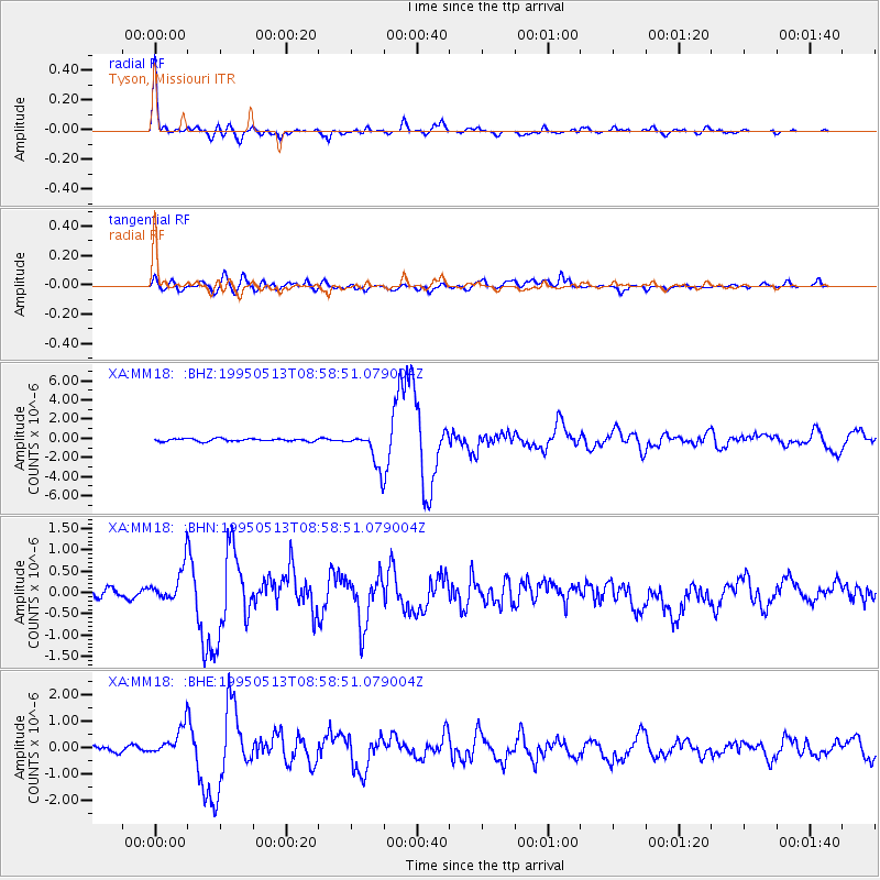
Signal To Noise
| Channel | StoN | STA | LTA |
| XA:MM18: :BHN:19950513T08:58:51.079004Z | 3.2985153 | 4.4167348E-7 | 1.3390068E-7 |
| XA:MM18: :BHE:19950513T08:58:51.079004Z | 4.9799037 | 5.5169113E-7 | 1.1078349E-7 |
| XA:MM18: :BHZ:19950513T08:58:51.079004Z | 12.696329 | 1.8348335E-6 | 1.4451685E-7 |
| Arrivals |
| Ps | 3.4 SECOND |
| PpPs | 9.7 SECOND |
| PsPs/PpSs | 13 SECOND |


