You are here: Home > Network List > XA95 - Missouri to Massachusetts Transect Stations List
> Station MM18 Tyson, Missiouri > Earthquake Result Viewer
MM18 Tyson, Missiouri - Earthquake Result Viewer
| Earthquake location: |
Sakhalin, Russia |
| Earthquake latitude/longitude: |
52.6/142.8 |
| Earthquake time(UTC): |
1995/05/27 (147) 13:03:55 GMT |
| Earthquake Depth: |
33 km |
| Earthquake Magnitude: |
6.6 MB, 7.6 MS, 7.0 UNKNOWN, 7.0 MW |
| Earthquake Catalog/Contributor: |
WHDF/NEIC |
|
| Network: |
XA Missouri to Massachusetts Transect |
| Station: |
MM18 Tyson, Missiouri |
| Lat/Lon: |
38.53 N/90.57 W |
| Elevation: |
186 m |
|
| Distance: |
78.1 deg |
| Az: |
40.038 deg |
| Baz: |
329.954 deg |
| Ray Param: |
0.049807552 |
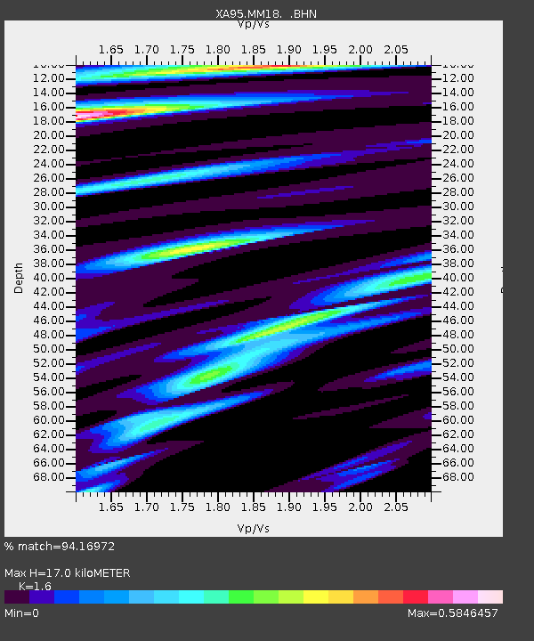
| Estimated Moho Depth: |
17.0 km |
| Estimated Crust Vp/Vs: |
1.60 |
| Assumed Crust Vp: |
6.498 km/s |
| Estimated Crust Vs: |
4.061 km/s |
| Estimated Crust Poisson's Ratio: |
0.18 |
|
| Radial Match: |
94.16972 % |
| Radial Bump: |
400 |
| Transverse Match: |
84.983925 % |
| Transverse Bump: |
400 |
| SOD ConfigId: |
6273 |
| Insert Time: |
2010-02-26 17:57:24.362 +0000 |
| GWidth: |
2.5 |
| Max Bumps: |
400 |
| Tol: |
0.001 |
|
Signal To Noise
| Channel | StoN | STA | LTA |
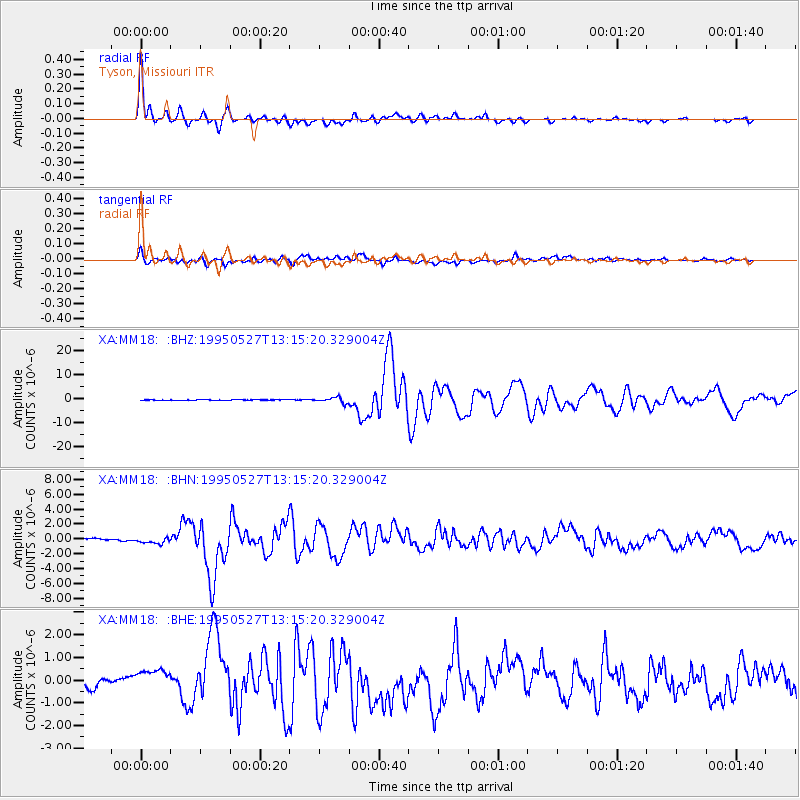
| XA:MM18: :BHN:19950527T13:15:20.329004Z | 2.355079 | 5.9388833E-7 | 2.5217344E-7 |
| XA:MM18: :BHE:19950527T13:15:20.329004Z | 1.58729 | 6.890823E-7 | 4.34125E-7 |
| XA:MM18: :BHZ:19950527T13:15:20.329004Z | 15.179787 | 1.1148762E-6 | 7.344479E-8 |
| Arrivals |
| Ps | 1.6 SECOND |
| PpPs | 6.6 SECOND |
| PsPs/PpSs | 8.2 SECOND |


