You are here: Home > Network List > GT - Global Telemetered Seismograph Network (USAF/USGS) Stations List
> Station LPAZ La Paz , Bolivia > Earthquake Result Viewer
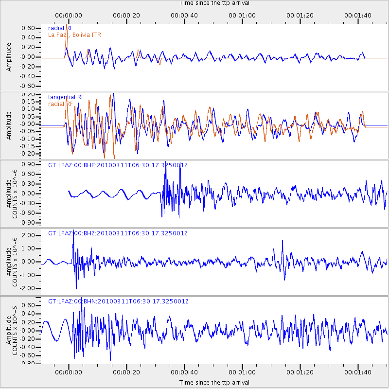
LPAZ La Paz , Bolivia - Earthquake Result Viewer
*The percent match for this event was below the threshold and hence no stack was calculated.
| Earthquake location: |
South Sandwich Islands Region |
| Earthquake latitude/longitude: |
-57.3/-27.9 |
| Earthquake time(UTC): |
2010/03/11 (070) 06:22:18 GMT |
| Earthquake Depth: |
308 km |
| Earthquake Magnitude: |
5.7 MB, 5.6 MW, 5.5 MW |
| Earthquake Catalog/Contributor: |
WHDF/NEIC |
|
| Network: |
GT Global Telemetered Seismograph Network (USAF/USGS) |
| Station: |
LPAZ La Paz , Bolivia |
| Lat/Lon: |
16.17 S/68.08 W |
| Elevation: |
4817 m |
|
| Distance: |
50.9 deg |
| Az: |
306.976 deg |
| Baz: |
153.162 deg |
| Ray Param: |
$rayparam |
*The percent match for this event was below the threshold and hence was not used in the summary stack. |
|
| Radial Match: |
54.827663 % |
| Radial Bump: |
400 |
| Transverse Match: |
45.234375 % |
| Transverse Bump: |
400 |
| SOD ConfigId: |
299721 |
| Insert Time: |
2010-04-26 21:43:18.741 +0000 |
| GWidth: |
2.5 |
| Max Bumps: |
400 |
| Tol: |
0.001 |
|
Signal To Noise
| Channel | StoN | STA | LTA |
| GT:LPAZ:00:BHZ:20100311T06:30:17.325001Z | 7.1195526 | 6.791005E-7 | 9.5385275E-8 |
| GT:LPAZ:00:BHN:20100311T06:30:17.325001Z | 2.1497796 | 2.9477994E-7 | 1.3712102E-7 |
| GT:LPAZ:00:BHE:20100311T06:30:17.325001Z | 3.7316625 | 2.8997988E-7 | 7.7707966E-8 |
| Arrivals |
| Ps | |
| PpPs | |
| PsPs/PpSs | |


