You are here: Home > Network List > XA95 - Missouri to Massachusetts Transect Stations List
> Station MM18 Tyson, Missiouri > Earthquake Result Viewer
MM18 Tyson, Missiouri - Earthquake Result Viewer
| Earthquake location: |
Near Coast Of Peru |
| Earthquake latitude/longitude: |
-10.5/-78.7 |
| Earthquake time(UTC): |
1995/09/23 (266) 22:31:58 GMT |
| Earthquake Depth: |
73 km |
| Earthquake Magnitude: |
5.9 MB, 6.5 UNKNOWN, 6.4 MW |
| Earthquake Catalog/Contributor: |
WHDF/NEIC |
|
| Network: |
XA Missouri to Massachusetts Transect |
| Station: |
MM18 Tyson, Missiouri |
| Lat/Lon: |
38.53 N/90.57 W |
| Elevation: |
186 m |
|
| Distance: |
50.0 deg |
| Az: |
347.849 deg |
| Baz: |
164.698 deg |
| Ray Param: |
0.068096295 |
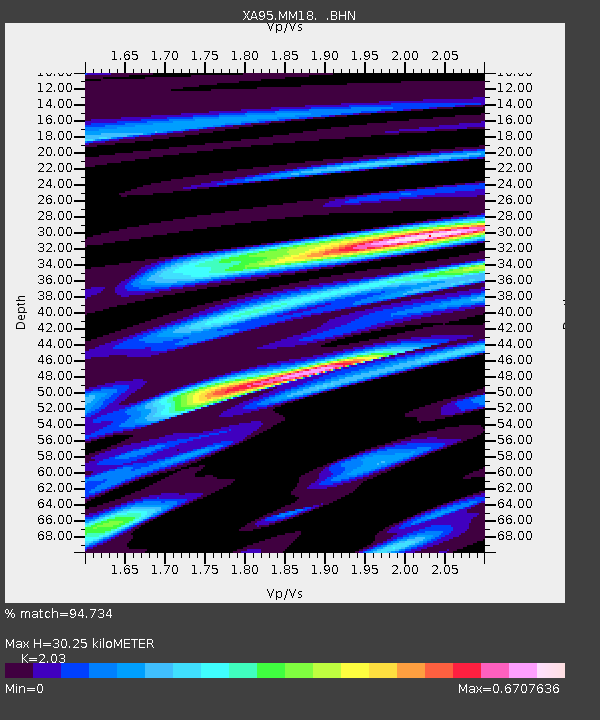
| Estimated Moho Depth: |
30.25 km |
| Estimated Crust Vp/Vs: |
2.03 |
| Assumed Crust Vp: |
6.498 km/s |
| Estimated Crust Vs: |
3.201 km/s |
| Estimated Crust Poisson's Ratio: |
0.34 |
|
| Radial Match: |
94.734 % |
| Radial Bump: |
397 |
| Transverse Match: |
78.61357 % |
| Transverse Bump: |
400 |
| SOD ConfigId: |
6273 |
| Insert Time: |
2010-02-26 17:57:26.685 +0000 |
| GWidth: |
2.5 |
| Max Bumps: |
400 |
| Tol: |
0.001 |
|
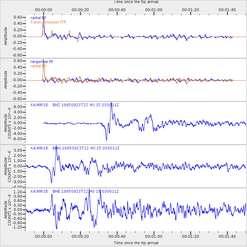
Signal To Noise
| Channel | StoN | STA | LTA |
| XA:MM18: :BHN:19950923T22:40:15.030011Z | 8.725556 | 1.109428E-6 | 1.2714696E-7 |
| XA:MM18: :BHE:19950923T22:40:15.030011Z | 2.9642892 | 3.262807E-7 | 1.1007048E-7 |
| XA:MM18: :BHZ:19950923T22:40:15.030011Z | 15.2521 | 2.1703622E-6 | 1.4229924E-7 |
| Arrivals |
| Ps | 5.0 SECOND |
| PpPs | 13 SECOND |
| PsPs/PpSs | 18 SECOND |


