You are here: Home > Network List > G - GEOSCOPE Stations List
> Station INU Inuyama, Japan > Earthquake Result Viewer
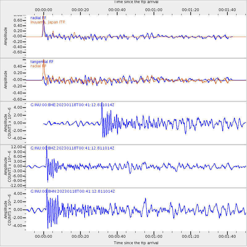
INU Inuyama, Japan - Earthquake Result Viewer
*The percent match for this event was below the threshold and hence no stack was calculated.
| Earthquake location: |
Minahassa Peninsula, Sulawesi |
| Earthquake latitude/longitude: |
-0.0/123.2 |
| Earthquake time(UTC): |
2023/01/18 (018) 00:34:43 GMT |
| Earthquake Depth: |
147 km |
| Earthquake Magnitude: |
6.1 mww |
| Earthquake Catalog/Contributor: |
NEIC PDE/us |
|
| Network: |
G GEOSCOPE |
| Station: |
INU Inuyama, Japan |
| Lat/Lon: |
35.35 N/137.03 E |
| Elevation: |
132 m |
|
| Distance: |
37.5 deg |
| Az: |
18.746 deg |
| Baz: |
203.15 deg |
| Ray Param: |
$rayparam |
*The percent match for this event was below the threshold and hence was not used in the summary stack. |
|
| Radial Match: |
75.19457 % |
| Radial Bump: |
400 |
| Transverse Match: |
65.36569 % |
| Transverse Bump: |
400 |
| SOD ConfigId: |
29823551 |
| Insert Time: |
2023-02-01 00:44:28.256 +0000 |
| GWidth: |
2.5 |
| Max Bumps: |
400 |
| Tol: |
0.001 |
|
Signal To Noise
| Channel | StoN | STA | LTA |
| G:INU:00:BHZ:20230118T00:41:12.811014Z | 7.914505 | 4.150954E-6 | 5.244742E-7 |
| G:INU:00:BHN:20230118T00:41:12.811014Z | 4.906303 | 2.0843486E-6 | 4.248308E-7 |
| G:INU:00:BHE:20230118T00:41:12.811014Z | 6.4273634 | 1.9434585E-6 | 3.023726E-7 |
| Arrivals |
| Ps | |
| PpPs | |
| PsPs/PpSs | |


