You are here: Home > Network List > XA95 - Missouri to Massachusetts Transect Stations List
> Station MM18 Tyson, Missiouri > Earthquake Result Viewer
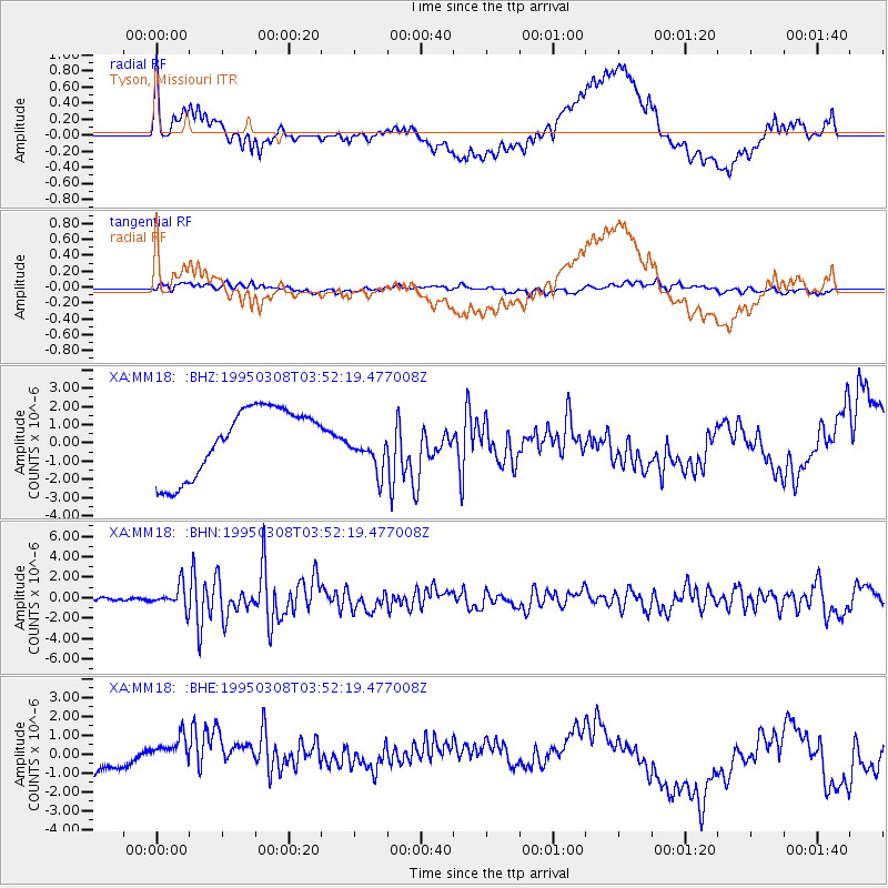
MM18 Tyson, Missiouri - Earthquake Result Viewer
*The percent match for this event was below the threshold and hence no stack was calculated.
| Earthquake location: |
Leeward Islands |
| Earthquake latitude/longitude: |
16.6/-59.6 |
| Earthquake time(UTC): |
1995/03/08 (067) 03:45:59 GMT |
| Earthquake Depth: |
15 km |
| Earthquake Magnitude: |
6.3 MB, 6.2 MS, 6.4 UNKNOWN, 6.1 MD |
| Earthquake Catalog/Contributor: |
WHDF/NEIC |
|
| Network: |
XA Missouri to Massachusetts Transect |
| Station: |
MM18 Tyson, Missiouri |
| Lat/Lon: |
38.53 N/90.57 W |
| Elevation: |
186 m |
|
| Distance: |
34.9 deg |
| Az: |
315.047 deg |
| Baz: |
120.239 deg |
| Ray Param: |
$rayparam |
*The percent match for this event was below the threshold and hence was not used in the summary stack. |
|
| Radial Match: |
53.37871 % |
| Radial Bump: |
400 |
| Transverse Match: |
40.40486 % |
| Transverse Bump: |
400 |
| SOD ConfigId: |
4480 |
| Insert Time: |
2010-02-26 17:57:28.064 +0000 |
| GWidth: |
2.5 |
| Max Bumps: |
400 |
| Tol: |
0.001 |
|
Signal To Noise
| Channel | StoN | STA | LTA |
| XA:MM18: :BHN:19950308T03:52:19.477008Z | 5.4347053 | 1.1127875E-6 | 2.0475579E-7 |
| XA:MM18: :BHE:19950308T03:52:19.477008Z | 0.71062857 | 9.026729E-7 | 1.2702457E-6 |
| XA:MM18: :BHZ:19950308T03:52:19.477008Z | 0.66922414 | 1.2324107E-6 | 1.8415514E-6 |
| Arrivals |
| Ps | |
| PpPs | |
| PsPs/PpSs | |


