You are here: Home > Network List > TM - Thai Seismic Monitoring Network Stations List
> Station CMAI AngKang, ChiangMai > Earthquake Result Viewer
CMAI AngKang, ChiangMai - Earthquake Result Viewer
| Earthquake location: |
Minahassa Peninsula, Sulawesi |
| Earthquake latitude/longitude: |
-0.0/123.2 |
| Earthquake time(UTC): |
2023/01/18 (018) 00:34:43 GMT |
| Earthquake Depth: |
147 km |
| Earthquake Magnitude: |
6.1 mww |
| Earthquake Catalog/Contributor: |
NEIC PDE/us |
|
| Network: |
TM Thai Seismic Monitoring Network |
| Station: |
CMAI AngKang, ChiangMai |
| Lat/Lon: |
19.93 N/99.05 E |
| Elevation: |
1544 m |
|
| Distance: |
30.9 deg |
| Az: |
311.438 deg |
| Baz: |
127.172 deg |
| Ray Param: |
0.07891062 |
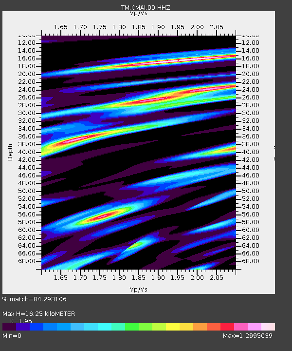
| Estimated Moho Depth: |
16.25 km |
| Estimated Crust Vp/Vs: |
1.95 |
| Assumed Crust Vp: |
6.35 km/s |
| Estimated Crust Vs: |
3.256 km/s |
| Estimated Crust Poisson's Ratio: |
0.32 |
|
| Radial Match: |
84.293106 % |
| Radial Bump: |
400 |
| Transverse Match: |
76.28583 % |
| Transverse Bump: |
400 |
| SOD ConfigId: |
29823551 |
| Insert Time: |
2023-02-01 00:49:01.388 +0000 |
| GWidth: |
2.5 |
| Max Bumps: |
400 |
| Tol: |
0.001 |
|

Signal To Noise
| Channel | StoN | STA | LTA |
| TM:CMAI:00:HHZ:20230118T00:40:15.759989Z | 19.272799 | 1.874704E-6 | 9.727202E-8 |
| TM:CMAI:00:HHN:20230118T00:40:15.759989Z | 7.6443577 | 9.773788E-7 | 1.2785624E-7 |
| TM:CMAI:00:HHE:20230118T00:40:15.759989Z | 12.084912 | 1.4502407E-6 | 1.2000423E-7 |
| Arrivals |
| Ps | 2.6 SECOND |
| PpPs | 7.0 SECOND |
| PsPs/PpSs | 9.6 SECOND |


