You are here: Home > Network List > XA95 - Missouri to Massachusetts Transect Stations List
> Station MM18 Tyson, Missiouri > Earthquake Result Viewer
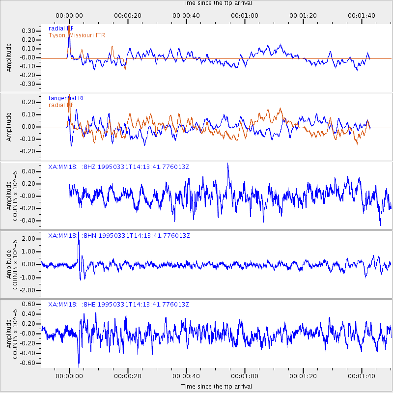
MM18 Tyson, Missiouri - Earthquake Result Viewer
*The percent match for this event was below the threshold and hence no stack was calculated.
| Earthquake location: |
Sea Of Japan |
| Earthquake latitude/longitude: |
38.2/135.1 |
| Earthquake time(UTC): |
1995/03/31 (090) 14:01:40 GMT |
| Earthquake Depth: |
365 km |
| Earthquake Magnitude: |
6.0 MB, 6.2 UNKNOWN, 6.3 MW |
| Earthquake Catalog/Contributor: |
WHDF/NEIC |
|
| Network: |
XA Missouri to Massachusetts Transect |
| Station: |
MM18 Tyson, Missiouri |
| Lat/Lon: |
38.53 N/90.57 W |
| Elevation: |
186 m |
|
| Distance: |
92.9 deg |
| Az: |
34.15 deg |
| Baz: |
325.648 deg |
| Ray Param: |
$rayparam |
*The percent match for this event was below the threshold and hence was not used in the summary stack. |
|
| Radial Match: |
45.473145 % |
| Radial Bump: |
400 |
| Transverse Match: |
54.856792 % |
| Transverse Bump: |
400 |
| SOD ConfigId: |
4480 |
| Insert Time: |
2010-02-26 17:57:30.355 +0000 |
| GWidth: |
2.5 |
| Max Bumps: |
400 |
| Tol: |
0.001 |
|
Signal To Noise
| Channel | StoN | STA | LTA |
| XA:MM18: :BHN:19950331T14:13:41.776013Z | 7.3019567 | 6.744199E-7 | 9.2361525E-8 |
| XA:MM18: :BHE:19950331T14:13:41.776013Z | 2.0124128 | 1.8883752E-7 | 9.383637E-8 |
| XA:MM18: :BHZ:19950331T14:13:41.776013Z | 1.1075908 | 1.0529557E-7 | 9.506721E-8 |
| Arrivals |
| Ps | |
| PpPs | |
| PsPs/PpSs | |


