You are here: Home > Network List > AK - Alaska Regional Network Stations List
> Station BRLK Bradley Lake > Earthquake Result Viewer
BRLK Bradley Lake - Earthquake Result Viewer
| Earthquake location: |
Northern Molucca Sea |
| Earthquake latitude/longitude: |
2.7/127.1 |
| Earthquake time(UTC): |
2023/01/18 (018) 06:06:11 GMT |
| Earthquake Depth: |
29 km |
| Earthquake Magnitude: |
7.0 mwc |
| Earthquake Catalog/Contributor: |
NEIC PDE/us |
|
| Network: |
AK Alaska Regional Network |
| Station: |
BRLK Bradley Lake |
| Lat/Lon: |
59.75 N/150.91 W |
| Elevation: |
409 m |
|
| Distance: |
83.6 deg |
| Az: |
30.299 deg |
| Baz: |
264.492 deg |
| Ray Param: |
0.04601999 |
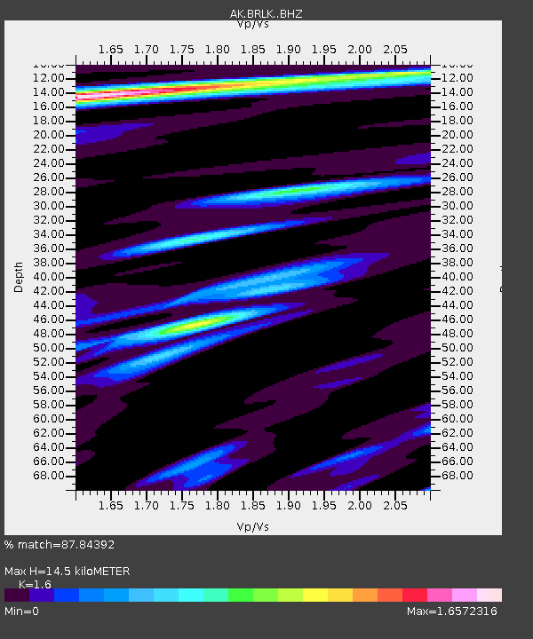
| Estimated Moho Depth: |
14.5 km |
| Estimated Crust Vp/Vs: |
1.60 |
| Assumed Crust Vp: |
6.24 km/s |
| Estimated Crust Vs: |
3.9 km/s |
| Estimated Crust Poisson's Ratio: |
0.18 |
|
| Radial Match: |
87.84392 % |
| Radial Bump: |
400 |
| Transverse Match: |
76.099915 % |
| Transverse Bump: |
400 |
| SOD ConfigId: |
29823551 |
| Insert Time: |
2023-02-01 06:07:10.284 +0000 |
| GWidth: |
2.5 |
| Max Bumps: |
400 |
| Tol: |
0.001 |
|

Signal To Noise
| Channel | StoN | STA | LTA |
| AK:BRLK: :BHZ:20230118T06:18:05.767989Z | 3.1497295 | 2.734254E-6 | 8.6809166E-7 |
| AK:BRLK: :BHN:20230118T06:18:05.767989Z | 0.92994905 | 8.4198257E-7 | 9.054072E-7 |
| AK:BRLK: :BHE:20230118T06:18:05.767989Z | 1.4853919 | 1.4570641E-6 | 9.80929E-7 |
| Arrivals |
| Ps | 1.4 SECOND |
| PpPs | 5.9 SECOND |
| PsPs/PpSs | 7.3 SECOND |


