You are here: Home > Network List > XA95 - Missouri to Massachusetts Transect Stations List
> Station MM18 Tyson, Missiouri > Earthquake Result Viewer
MM18 Tyson, Missiouri - Earthquake Result Viewer
*The percent match for this event was below the threshold and hence no stack was calculated.
| Earthquake location: |
Off Coast Of Ecuador |
| Earthquake latitude/longitude: |
1.2/-84.9 |
| Earthquake time(UTC): |
1995/04/27 (117) 12:44:38 GMT |
| Earthquake Depth: |
10 km |
| Earthquake Magnitude: |
5.3 MB, 6.0 MS, 6.2 UNKNOWN, 6.2 MW |
| Earthquake Catalog/Contributor: |
WHDF/NEIC |
|
| Network: |
XA Missouri to Massachusetts Transect |
| Station: |
MM18 Tyson, Missiouri |
| Lat/Lon: |
38.53 N/90.57 W |
| Elevation: |
186 m |
|
| Distance: |
37.5 deg |
| Az: |
352.728 deg |
| Baz: |
170.714 deg |
| Ray Param: |
$rayparam |
*The percent match for this event was below the threshold and hence was not used in the summary stack. |
|
| Radial Match: |
21.012276 % |
| Radial Bump: |
400 |
| Transverse Match: |
13.013433 % |
| Transverse Bump: |
400 |
| SOD ConfigId: |
4480 |
| Insert Time: |
2010-02-26 17:57:31.564 +0000 |
| GWidth: |
2.5 |
| Max Bumps: |
400 |
| Tol: |
0.001 |
|
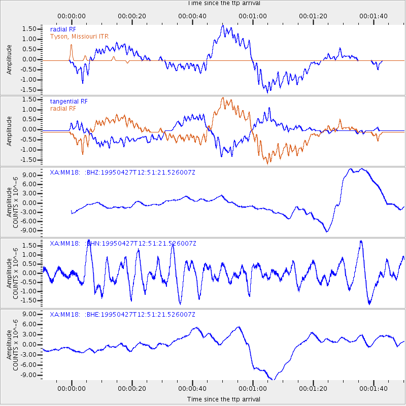
Signal To Noise
| Channel | StoN | STA | LTA |
| XA:MM18: :BHN:19950427T12:51:21.526007Z | 1.2477642 | 3.489851E-7 | 2.7968838E-7 |
| XA:MM18: :BHE:19950427T12:51:21.526007Z | 1.2926775 | 2.5958552E-6 | 2.008123E-6 |
| XA:MM18: :BHZ:19950427T12:51:21.526007Z | 1.7781521 | 1.6168725E-6 | 9.092993E-7 |
| Arrivals |
| Ps | |
| PpPs | |
| PsPs/PpSs | |


