You are here: Home > Network List > AV - Alaska Volcano Observatory Stations List
> Station AMKA Regional Station, Amchitka Island, Alaska > Earthquake Result Viewer
AMKA Regional Station, Amchitka Island, Alaska - Earthquake Result Viewer
| Earthquake location: |
Northern Molucca Sea |
| Earthquake latitude/longitude: |
2.7/127.1 |
| Earthquake time(UTC): |
2023/01/18 (018) 06:06:11 GMT |
| Earthquake Depth: |
29 km |
| Earthquake Magnitude: |
7.0 mwc |
| Earthquake Catalog/Contributor: |
NEIC PDE/us |
|
| Network: |
AV Alaska Volcano Observatory |
| Station: |
AMKA Regional Station, Amchitka Island, Alaska |
| Lat/Lon: |
51.38 N/179.30 E |
| Elevation: |
116 m |
|
| Distance: |
65.1 deg |
| Az: |
33.097 deg |
| Baz: |
240.494 deg |
| Ray Param: |
0.05842365 |
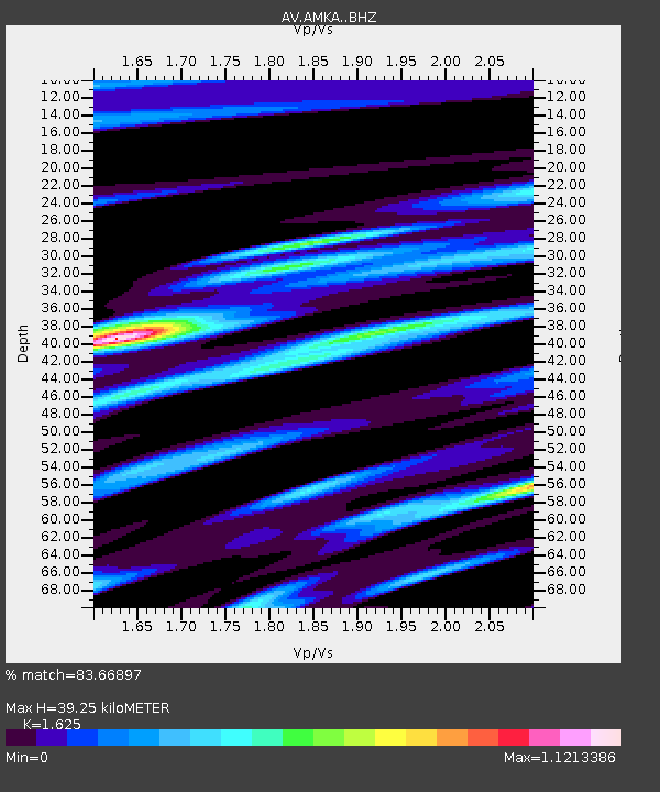
| Estimated Moho Depth: |
39.25 km |
| Estimated Crust Vp/Vs: |
1.62 |
| Assumed Crust Vp: |
6.183 km/s |
| Estimated Crust Vs: |
3.805 km/s |
| Estimated Crust Poisson's Ratio: |
0.20 |
|
| Radial Match: |
83.66897 % |
| Radial Bump: |
400 |
| Transverse Match: |
76.30384 % |
| Transverse Bump: |
400 |
| SOD ConfigId: |
29823551 |
| Insert Time: |
2023-02-01 06:12:02.048 +0000 |
| GWidth: |
2.5 |
| Max Bumps: |
400 |
| Tol: |
0.001 |
|

Signal To Noise
| Channel | StoN | STA | LTA |
| AV:AMKA: :BHZ:20230118T06:16:18.65898Z | 3.0076277 | 5.8808916E-7 | 1.9553256E-7 |
| AV:AMKA: :BHN:20230118T06:16:18.65898Z | 0.7781038 | 1.7121036E-7 | 2.2003537E-7 |
| AV:AMKA: :BHE:20230118T06:16:18.65898Z | 1.0937848 | 2.1980483E-7 | 2.0095801E-7 |
| Arrivals |
| Ps | 4.1 SECOND |
| PpPs | 16 SECOND |
| PsPs/PpSs | 20 SECOND |


