You are here: Home > Network List > AV - Alaska Volcano Observatory Stations List
> Station ISLZ Lazaref River, Shishaldin Volcano, Alaska > Earthquake Result Viewer
ISLZ Lazaref River, Shishaldin Volcano, Alaska - Earthquake Result Viewer
| Earthquake location: |
Northern Molucca Sea |
| Earthquake latitude/longitude: |
2.7/127.1 |
| Earthquake time(UTC): |
2023/01/18 (018) 06:06:11 GMT |
| Earthquake Depth: |
29 km |
| Earthquake Magnitude: |
7.0 mwc |
| Earthquake Catalog/Contributor: |
NEIC PDE/us |
|
| Network: |
AV Alaska Volcano Observatory |
| Station: |
ISLZ Lazaref River, Shishaldin Volcano, Alaska |
| Lat/Lon: |
54.72 N/163.71 W |
| Elevation: |
634 m |
|
| Distance: |
75.9 deg |
| Az: |
34.007 deg |
| Baz: |
254.382 deg |
| Ray Param: |
0.05134411 |
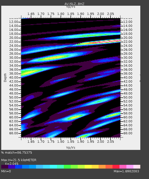
| Estimated Moho Depth: |
21.5 km |
| Estimated Crust Vp/Vs: |
2.05 |
| Assumed Crust Vp: |
5.989 km/s |
| Estimated Crust Vs: |
2.929 km/s |
| Estimated Crust Poisson's Ratio: |
0.34 |
|
| Radial Match: |
86.75375 % |
| Radial Bump: |
400 |
| Transverse Match: |
83.93469 % |
| Transverse Bump: |
400 |
| SOD ConfigId: |
29823551 |
| Insert Time: |
2023-02-01 06:13:03.603 +0000 |
| GWidth: |
2.5 |
| Max Bumps: |
400 |
| Tol: |
0.001 |
|

Signal To Noise
| Channel | StoN | STA | LTA |
| AV:ISLZ: :BHZ:20230118T06:17:23.879988Z | 3.7068083 | 2.7252183E-6 | 7.3519266E-7 |
| AV:ISLZ: :BHN:20230118T06:17:23.879988Z | 0.7143555 | 9.3551984E-7 | 1.3095998E-6 |
| AV:ISLZ: :BHE:20230118T06:17:23.879988Z | 1.1273332 | 1.4965681E-6 | 1.3275295E-6 |
| Arrivals |
| Ps | 3.8 SECOND |
| PpPs | 11 SECOND |
| PsPs/PpSs | 15 SECOND |


