You are here: Home > Network List > AV - Alaska Volcano Observatory Stations List
> Station MTBL Table Top, Makushin Volcano, Alaska > Earthquake Result Viewer
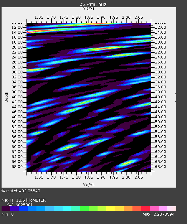
MTBL Table Top, Makushin Volcano, Alaska - Earthquake Result Viewer
| Earthquake location: |
Northern Molucca Sea |
| Earthquake latitude/longitude: |
2.7/127.1 |
| Earthquake time(UTC): |
2023/01/18 (018) 06:06:11 GMT |
| Earthquake Depth: |
29 km |
| Earthquake Magnitude: |
7.0 mwc |
| Earthquake Catalog/Contributor: |
NEIC PDE/us |
|
| Network: |
AV Alaska Volcano Observatory |
| Station: |
MTBL Table Top, Makushin Volcano, Alaska |
| Lat/Lon: |
53.97 N/166.68 W |
| Elevation: |
810 m |
|
| Distance: |
74.0 deg |
| Az: |
34.239 deg |
| Baz: |
252.036 deg |
| Ray Param: |
0.052610893 |
| Estimated Moho Depth: |
13.5 km |
| Estimated Crust Vp/Vs: |
1.60 |
| Assumed Crust Vp: |
3.943 km/s |
| Estimated Crust Vs: |
2.461 km/s |
| Estimated Crust Poisson's Ratio: |
0.18 |
|
| Radial Match: |
92.05548 % |
| Radial Bump: |
400 |
| Transverse Match: |
90.58147 % |
| Transverse Bump: |
400 |
| SOD ConfigId: |
29823551 |
| Insert Time: |
2023-02-01 06:13:49.423 +0000 |
| GWidth: |
2.5 |
| Max Bumps: |
400 |
| Tol: |
0.001 |
|

Signal To Noise
| Channel | StoN | STA | LTA |
| AV:MTBL: :BHZ:20230118T06:17:13.019026Z | 2.2504644 | 2.6712723E-6 | 1.1869872E-6 |
| AV:MTBL: :BHN:20230118T06:17:13.019026Z | 2.1908062 | 3.1496438E-6 | 1.4376644E-6 |
| AV:MTBL: :BHE:20230118T06:17:13.019026Z | 1.2237945 | 2.7592775E-6 | 2.2546903E-6 |
| Arrivals |
| Ps | 2.1 SECOND |
| PpPs | 8.8 SECOND |
| PsPs/PpSs | 11 SECOND |


