You are here: Home > Network List > CN - Canadian National Seismograph Network Stations List
> Station BRWY Burwash Landing, YT, CA > Earthquake Result Viewer
BRWY Burwash Landing, YT, CA - Earthquake Result Viewer
| Earthquake location: |
Northern Molucca Sea |
| Earthquake latitude/longitude: |
2.7/127.1 |
| Earthquake time(UTC): |
2023/01/18 (018) 06:06:11 GMT |
| Earthquake Depth: |
29 km |
| Earthquake Magnitude: |
7.0 mwc |
| Earthquake Catalog/Contributor: |
NEIC PDE/us |
|
| Network: |
CN Canadian National Seismograph Network |
| Station: |
BRWY Burwash Landing, YT, CA |
| Lat/Lon: |
61.37 N/139.03 W |
| Elevation: |
802 m |
|
| Distance: |
89.5 deg |
| Az: |
28.72 deg |
| Baz: |
274.73 deg |
| Ray Param: |
0.041774895 |
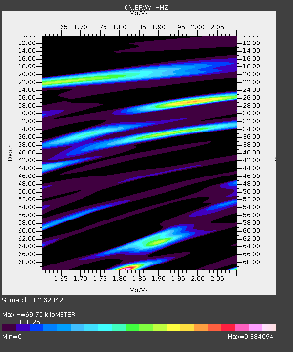
| Estimated Moho Depth: |
69.75 km |
| Estimated Crust Vp/Vs: |
1.81 |
| Assumed Crust Vp: |
6.566 km/s |
| Estimated Crust Vs: |
3.623 km/s |
| Estimated Crust Poisson's Ratio: |
0.28 |
|
| Radial Match: |
82.62342 % |
| Radial Bump: |
400 |
| Transverse Match: |
73.68562 % |
| Transverse Bump: |
400 |
| SOD ConfigId: |
29823551 |
| Insert Time: |
2023-02-01 06:15:23.816 +0000 |
| GWidth: |
2.5 |
| Max Bumps: |
400 |
| Tol: |
0.001 |
|

Signal To Noise
| Channel | StoN | STA | LTA |
| CN:BRWY: :HHZ:20230118T06:18:34.369979Z | 2.9210534 | 8.7597033E-7 | 2.9988166E-7 |
| CN:BRWY: :HHN:20230118T06:18:34.369979Z | 1.3233215 | 4.5677646E-7 | 3.4517424E-7 |
| CN:BRWY: :HHE:20230118T06:18:34.369979Z | 0.437467 | 1.8964617E-7 | 4.3350968E-7 |
| Arrivals |
| Ps | 8.8 SECOND |
| PpPs | 29 SECOND |
| PsPs/PpSs | 38 SECOND |


