You are here: Home > Network List > II - Global Seismograph Network (GSN - IRIS/IDA) Stations List
> Station COCO West Island, Cocos (Keeling) Islands > Earthquake Result Viewer
COCO West Island, Cocos (Keeling) Islands - Earthquake Result Viewer
| Earthquake location: |
Northern Molucca Sea |
| Earthquake latitude/longitude: |
2.7/127.1 |
| Earthquake time(UTC): |
2023/01/18 (018) 06:06:11 GMT |
| Earthquake Depth: |
29 km |
| Earthquake Magnitude: |
7.0 mwc |
| Earthquake Catalog/Contributor: |
NEIC PDE/us |
|
| Network: |
II Global Seismograph Network (GSN - IRIS/IDA) |
| Station: |
COCO West Island, Cocos (Keeling) Islands |
| Lat/Lon: |
12.19 S/96.83 E |
| Elevation: |
1.0 m |
|
| Distance: |
33.5 deg |
| Az: |
243.109 deg |
| Baz: |
65.664 deg |
| Ray Param: |
0.07815595 |
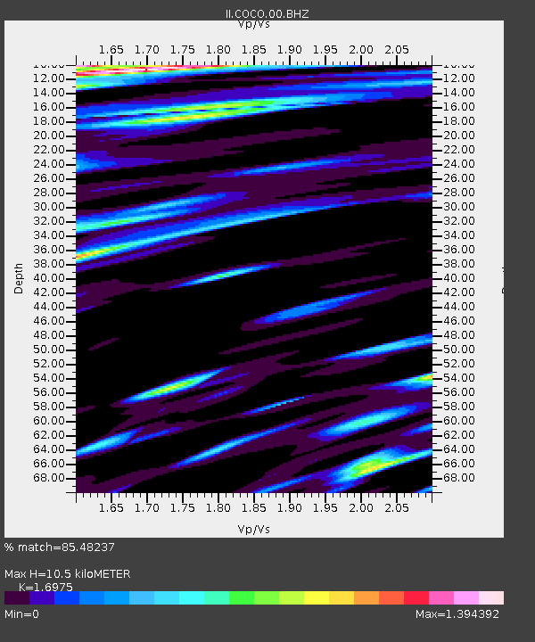
| Estimated Moho Depth: |
10.5 km |
| Estimated Crust Vp/Vs: |
1.70 |
| Assumed Crust Vp: |
4.24 km/s |
| Estimated Crust Vs: |
2.498 km/s |
| Estimated Crust Poisson's Ratio: |
0.23 |
|
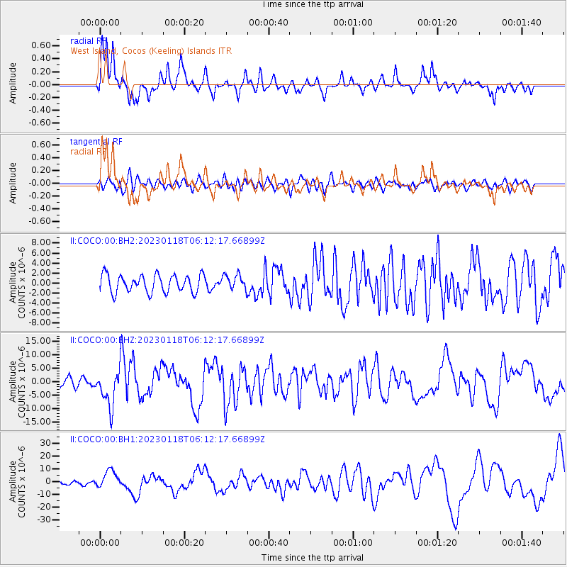
| Radial Match: |
85.48237 % |
| Radial Bump: |
297 |
| Transverse Match: |
64.99108 % |
| Transverse Bump: |
400 |
| SOD ConfigId: |
29823551 |
| Insert Time: |
2023-02-01 06:17:05.756 +0000 |
| GWidth: |
2.5 |
| Max Bumps: |
400 |
| Tol: |
0.001 |
|
Signal To Noise
| Channel | StoN | STA | LTA |
| II:COCO:00:BHZ:20230118T06:12:17.66899Z | 5.213191 | 6.896865E-6 | 1.3229643E-6 |
| II:COCO:00:BH1:20230118T06:12:17.66899Z | 3.7944658 | 6.975328E-6 | 1.8382898E-6 |
| II:COCO:00:BH2:20230118T06:12:17.66899Z | 0.86619234 | 1.5211892E-6 | 1.7561795E-6 |
| Arrivals |
| Ps | 1.8 SECOND |
| PpPs | 6.5 SECOND |
| PsPs/PpSs | 8.2 SECOND |


