You are here: Home > Network List > XA95 - Missouri to Massachusetts Transect Stations List
> Station MM18 Tyson, Missiouri > Earthquake Result Viewer
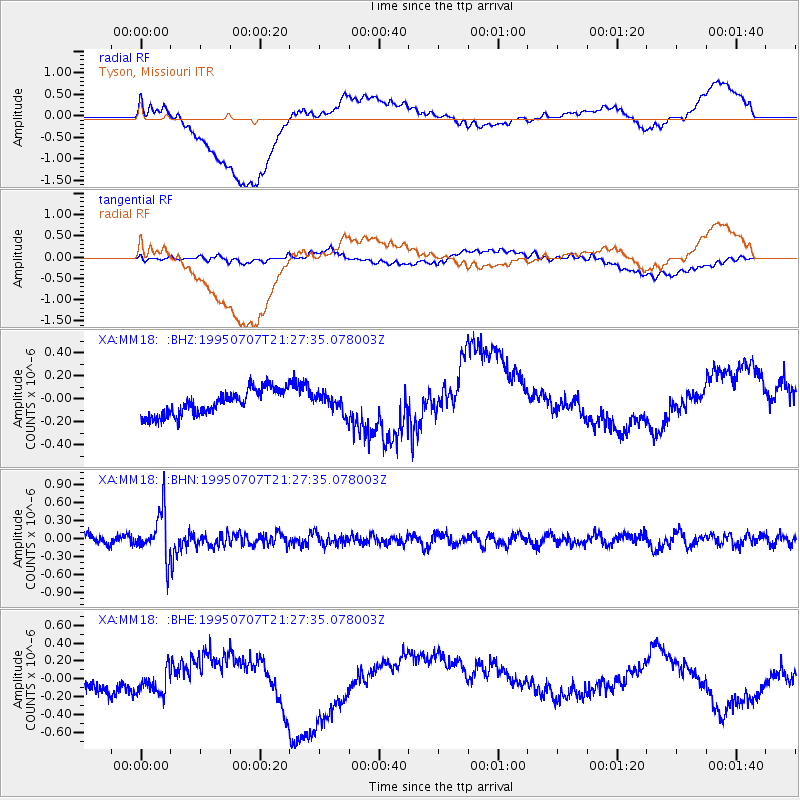
MM18 Tyson, Missiouri - Earthquake Result Viewer
*The percent match for this event was below the threshold and hence no stack was calculated.
| Earthquake location: |
Near S. Coast Of Honshu, Japan |
| Earthquake latitude/longitude: |
33.9/137.1 |
| Earthquake time(UTC): |
1995/07/07 (188) 21:15:18 GMT |
| Earthquake Depth: |
324 km |
| Earthquake Magnitude: |
5.8 MB, 6.0 UNKNOWN, 6.0 MW |
| Earthquake Catalog/Contributor: |
WHDF/NEIC |
|
| Network: |
XA Missouri to Massachusetts Transect |
| Station: |
MM18 Tyson, Missiouri |
| Lat/Lon: |
38.53 N/90.57 W |
| Elevation: |
186 m |
|
| Distance: |
95.4 deg |
| Az: |
35.634 deg |
| Baz: |
321.867 deg |
| Ray Param: |
$rayparam |
*The percent match for this event was below the threshold and hence was not used in the summary stack. |
|
| Radial Match: |
41.249096 % |
| Radial Bump: |
400 |
| Transverse Match: |
39.80083 % |
| Transverse Bump: |
400 |
| SOD ConfigId: |
4480 |
| Insert Time: |
2010-02-26 17:57:34.410 +0000 |
| GWidth: |
2.5 |
| Max Bumps: |
400 |
| Tol: |
0.001 |
|
Signal To Noise
| Channel | StoN | STA | LTA |
| XA:MM18: :BHN:19950707T21:27:35.078003Z | 5.552153 | 3.8952805E-7 | 7.0158016E-8 |
| XA:MM18: :BHE:19950707T21:27:35.078003Z | 1.0962086 | 2.0097464E-7 | 1.8333614E-7 |
| XA:MM18: :BHZ:19950707T21:27:35.078003Z | 0.67158836 | 7.367321E-8 | 1.09699954E-7 |
| Arrivals |
| Ps | |
| PpPs | |
| PsPs/PpSs | |


