You are here: Home > Network List > II - Global Seismograph Network (GSN - IRIS/IDA) Stations List
> Station PALK Pallekele, Sri Lanka > Earthquake Result Viewer
PALK Pallekele, Sri Lanka - Earthquake Result Viewer
| Earthquake location: |
Northern Molucca Sea |
| Earthquake latitude/longitude: |
2.7/127.1 |
| Earthquake time(UTC): |
2023/01/18 (018) 06:06:11 GMT |
| Earthquake Depth: |
29 km |
| Earthquake Magnitude: |
7.0 mwc |
| Earthquake Catalog/Contributor: |
NEIC PDE/us |
|
| Network: |
II Global Seismograph Network (GSN - IRIS/IDA) |
| Station: |
PALK Pallekele, Sri Lanka |
| Lat/Lon: |
7.27 N/80.70 E |
| Elevation: |
460 m |
|
| Distance: |
46.4 deg |
| Az: |
277.394 deg |
| Baz: |
93.142 deg |
| Ray Param: |
0.07064 |
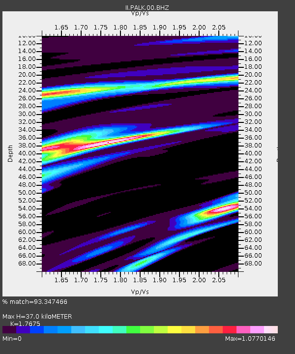
| Estimated Moho Depth: |
37.0 km |
| Estimated Crust Vp/Vs: |
1.77 |
| Assumed Crust Vp: |
6.545 km/s |
| Estimated Crust Vs: |
3.703 km/s |
| Estimated Crust Poisson's Ratio: |
0.26 |
|
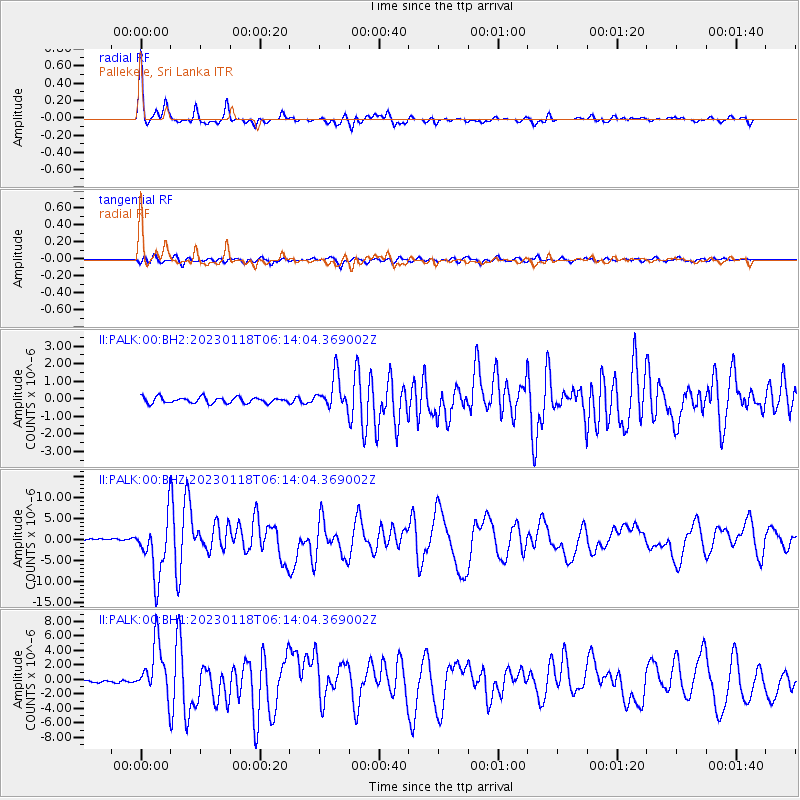
| Radial Match: |
93.347466 % |
| Radial Bump: |
349 |
| Transverse Match: |
82.18563 % |
| Transverse Bump: |
400 |
| SOD ConfigId: |
29823551 |
| Insert Time: |
2023-02-01 06:17:16.530 +0000 |
| GWidth: |
2.5 |
| Max Bumps: |
400 |
| Tol: |
0.001 |
|
Signal To Noise
| Channel | StoN | STA | LTA |
| II:PALK:00:BHZ:20230118T06:14:04.369002Z | 23.796814 | 6.9052726E-6 | 2.9017633E-7 |
| II:PALK:00:BH1:20230118T06:14:04.369002Z | 29.568792 | 3.6404572E-6 | 1.2311823E-7 |
| II:PALK:00:BH2:20230118T06:14:04.369002Z | 5.546449 | 9.3779437E-7 | 1.6908014E-7 |
| Arrivals |
| Ps | 4.6 SECOND |
| PpPs | 15 SECOND |
| PsPs/PpSs | 19 SECOND |


