You are here: Home > Network List > S1 - Australian Seismometers in Schools Stations List
> Station AUBSH Beerwah State High School > Earthquake Result Viewer
AUBSH Beerwah State High School - Earthquake Result Viewer
| Earthquake location: |
Northern Molucca Sea |
| Earthquake latitude/longitude: |
2.7/127.1 |
| Earthquake time(UTC): |
2023/01/18 (018) 06:06:11 GMT |
| Earthquake Depth: |
29 km |
| Earthquake Magnitude: |
7.0 mwc |
| Earthquake Catalog/Contributor: |
NEIC PDE/us |
|
| Network: |
S1 Australian Seismometers in Schools |
| Station: |
AUBSH Beerwah State High School |
| Lat/Lon: |
26.86 S/152.95 E |
| Elevation: |
26 m |
|
| Distance: |
38.6 deg |
| Az: |
141.305 deg |
| Baz: |
315.648 deg |
| Ray Param: |
0.075440206 |
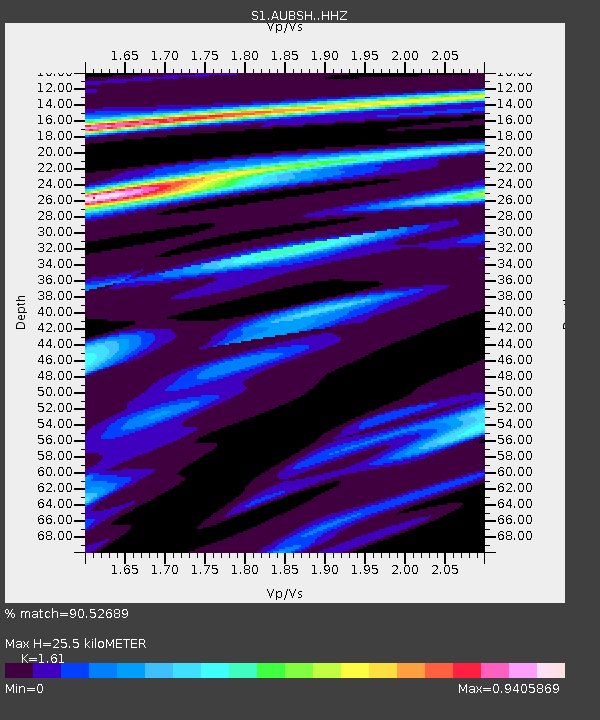
| Estimated Moho Depth: |
25.5 km |
| Estimated Crust Vp/Vs: |
1.61 |
| Assumed Crust Vp: |
6.472 km/s |
| Estimated Crust Vs: |
4.02 km/s |
| Estimated Crust Poisson's Ratio: |
0.19 |
|
| Radial Match: |
90.52689 % |
| Radial Bump: |
309 |
| Transverse Match: |
80.77703 % |
| Transverse Bump: |
400 |
| SOD ConfigId: |
29823551 |
| Insert Time: |
2023-02-01 06:20:07.129 +0000 |
| GWidth: |
2.5 |
| Max Bumps: |
400 |
| Tol: |
0.001 |
|

Signal To Noise
| Channel | StoN | STA | LTA |
| S1:AUBSH: :HHZ:20230118T06:13:01.319991Z | 14.667796 | 4.715403E-6 | 3.2147997E-7 |
| S1:AUBSH: :HHN:20230118T06:13:01.319991Z | 6.5709796 | 2.1718256E-6 | 3.305178E-7 |
| S1:AUBSH: :HHE:20230118T06:13:01.319991Z | 7.6610804 | 2.0229493E-6 | 2.6405536E-7 |
| Arrivals |
| Ps | 2.6 SECOND |
| PpPs | 9.5 SECOND |
| PsPs/PpSs | 12 SECOND |


