You are here: Home > Network List > XA95 - Missouri to Massachusetts Transect Stations List
> Station MM18 Tyson, Missiouri > Earthquake Result Viewer
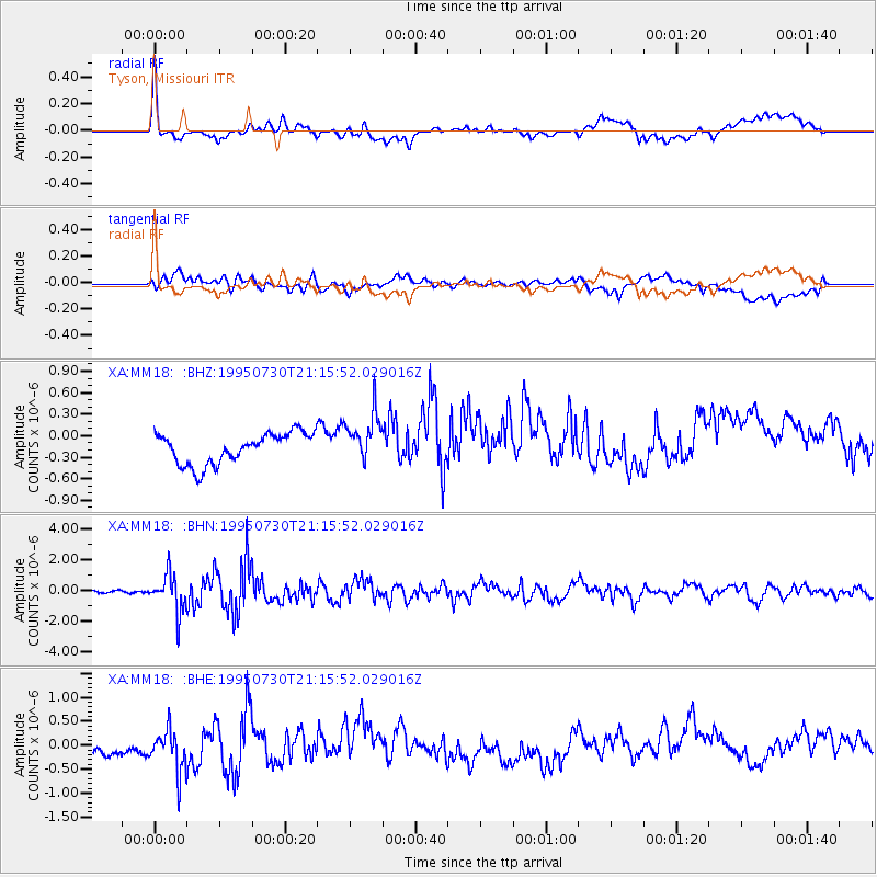
MM18 Tyson, Missiouri - Earthquake Result Viewer
*The percent match for this event was below the threshold and hence no stack was calculated.
| Earthquake location: |
Near Coast Of Northern Chile |
| Earthquake latitude/longitude: |
-23.3/-70.6 |
| Earthquake time(UTC): |
1995/07/30 (211) 21:05:50 GMT |
| Earthquake Depth: |
33 km |
| Earthquake Magnitude: |
5.6 MB, 5.6 MS, 5.4 UNKNOWN, 6.1 MW |
| Earthquake Catalog/Contributor: |
WHDF/NEIC |
|
| Network: |
XA Missouri to Massachusetts Transect |
| Station: |
MM18 Tyson, Missiouri |
| Lat/Lon: |
38.53 N/90.57 W |
| Elevation: |
186 m |
|
| Distance: |
64.3 deg |
| Az: |
342.7 deg |
| Baz: |
159.602 deg |
| Ray Param: |
$rayparam |
*The percent match for this event was below the threshold and hence was not used in the summary stack. |
|
| Radial Match: |
62.46048 % |
| Radial Bump: |
400 |
| Transverse Match: |
37.625916 % |
| Transverse Bump: |
400 |
| SOD ConfigId: |
4480 |
| Insert Time: |
2010-02-26 17:57:35.158 +0000 |
| GWidth: |
2.5 |
| Max Bumps: |
400 |
| Tol: |
0.001 |
|
Signal To Noise
| Channel | StoN | STA | LTA |
| XA:MM18: :BHN:19950730T21:15:52.029016Z | 16.233658 | 1.2321331E-6 | 7.5899905E-8 |
| XA:MM18: :BHE:19950730T21:15:52.029016Z | 2.1198418 | 4.6762045E-7 | 2.2059214E-7 |
| XA:MM18: :BHZ:19950730T21:15:52.029016Z | 1.5800008 | 3.3748128E-7 | 2.1359565E-7 |
| Arrivals |
| Ps | |
| PpPs | |
| PsPs/PpSs | |


