You are here: Home > Network List > IM - International Miscellaneous Stations Stations List
> Station TX32 TXAR Array, Lajitas, TX, USA > Earthquake Result Viewer
TX32 TXAR Array, Lajitas, TX, USA - Earthquake Result Viewer
| Earthquake location: |
Near Coast Of Central Chile |
| Earthquake latitude/longitude: |
-34.3/-71.9 |
| Earthquake time(UTC): |
2010/03/11 (070) 14:39:43 GMT |
| Earthquake Depth: |
11 km |
| Earthquake Magnitude: |
6.7 MB, 7.0 MS, 6.9 MW, 6.9 MW |
| Earthquake Catalog/Contributor: |
WHDF/NEIC |
|
| Network: |
IM International Miscellaneous Stations |
| Station: |
TX32 TXAR Array, Lajitas, TX, USA |
| Lat/Lon: |
29.33 N/103.67 W |
| Elevation: |
1013 m |
|
| Distance: |
70.0 deg |
| Az: |
330.713 deg |
| Baz: |
152.365 deg |
| Ray Param: |
0.055240583 |
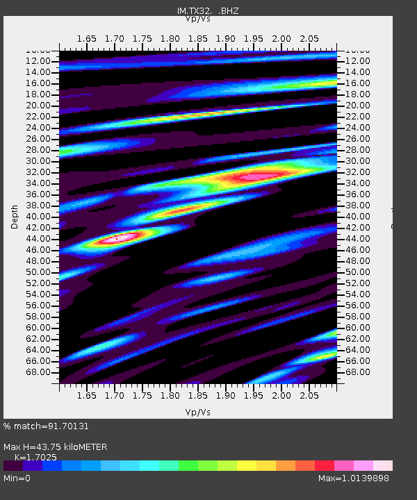
| Estimated Moho Depth: |
43.75 km |
| Estimated Crust Vp/Vs: |
1.70 |
| Assumed Crust Vp: |
6.419 km/s |
| Estimated Crust Vs: |
3.77 km/s |
| Estimated Crust Poisson's Ratio: |
0.24 |
|
| Radial Match: |
91.70131 % |
| Radial Bump: |
400 |
| Transverse Match: |
82.67578 % |
| Transverse Bump: |
400 |
| SOD ConfigId: |
299721 |
| Insert Time: |
2010-04-26 21:52:28.986 +0000 |
| GWidth: |
2.5 |
| Max Bumps: |
400 |
| Tol: |
0.001 |
|

Signal To Noise
| Channel | StoN | STA | LTA |
| IM:TX32: :BHZ:20100311T14:50:24.499988Z | 13.308417 | 7.2162074E-8 | 5.4222884E-9 |
| IM:TX32: :BHN:20100311T14:50:24.499988Z | 6.45232 | 4.0785704E-8 | 6.321091E-9 |
| IM:TX32: :BHE:20100311T14:50:24.499988Z | 3.318374 | 1.8494763E-8 | 5.5734417E-9 |
| Arrivals |
| Ps | 5.0 SECOND |
| PpPs | 18 SECOND |
| PsPs/PpSs | 23 SECOND |


