You are here: Home > Network List > XA95 - Missouri to Massachusetts Transect Stations List
> Station MM18 Tyson, Missiouri > Earthquake Result Viewer
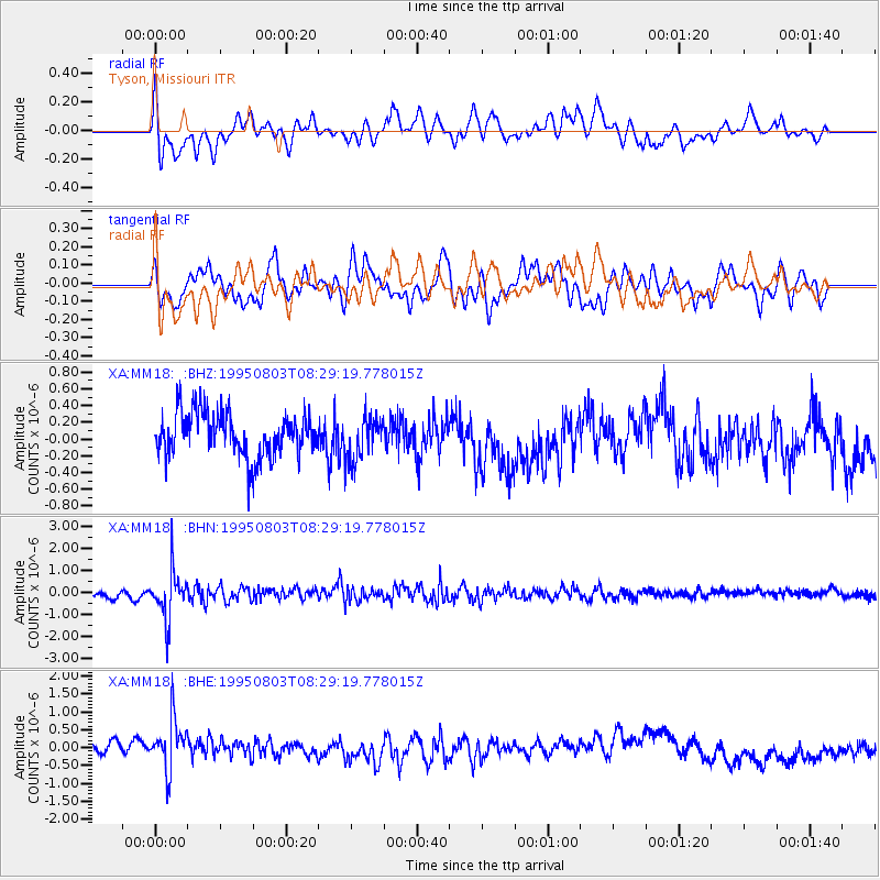
MM18 Tyson, Missiouri - Earthquake Result Viewer
*The percent match for this event was below the threshold and hence no stack was calculated.
| Earthquake location: |
Chile-Argentina Border Region |
| Earthquake latitude/longitude: |
-28.3/-69.2 |
| Earthquake time(UTC): |
1995/08/03 (215) 08:18:53 GMT |
| Earthquake Depth: |
104 km |
| Earthquake Magnitude: |
5.9 MB, 5.8 UNKNOWN, 5.9 MW |
| Earthquake Catalog/Contributor: |
WHDF/NEIC |
|
| Network: |
XA Missouri to Massachusetts Transect |
| Station: |
MM18 Tyson, Missiouri |
| Lat/Lon: |
38.53 N/90.57 W |
| Elevation: |
186 m |
|
| Distance: |
69.5 deg |
| Az: |
342.23 deg |
| Baz: |
159.941 deg |
| Ray Param: |
$rayparam |
*The percent match for this event was below the threshold and hence was not used in the summary stack. |
|
| Radial Match: |
49.20543 % |
| Radial Bump: |
400 |
| Transverse Match: |
46.644833 % |
| Transverse Bump: |
400 |
| SOD ConfigId: |
4480 |
| Insert Time: |
2010-02-26 17:57:36.035 +0000 |
| GWidth: |
2.5 |
| Max Bumps: |
400 |
| Tol: |
0.001 |
|
Signal To Noise
| Channel | StoN | STA | LTA |
| XA:MM18: :BHN:19950803T08:29:19.778015Z | 9.602247 | 1.0787336E-6 | 1.1234178E-7 |
| XA:MM18: :BHE:19950803T08:29:19.778015Z | 3.1265934 | 7.277346E-7 | 2.3275639E-7 |
| XA:MM18: :BHZ:19950803T08:29:19.778015Z | 1.0188022 | 2.7030984E-7 | 2.6532123E-7 |
| Arrivals |
| Ps | |
| PpPs | |
| PsPs/PpSs | |


