You are here: Home > Network List > AE - Arizona Broadband Seismic Network Stations List
> Station PRCT Prescott > Earthquake Result Viewer
PRCT Prescott - Earthquake Result Viewer
| Earthquake location: |
Leeward Islands |
| Earthquake latitude/longitude: |
16.2/-62.0 |
| Earthquake time(UTC): |
2023/01/20 (020) 11:23:40 GMT |
| Earthquake Depth: |
165 km |
| Earthquake Magnitude: |
5.8 Mi |
| Earthquake Catalog/Contributor: |
NEIC PDE/pt |
|
| Network: |
AE Arizona Broadband Seismic Network |
| Station: |
PRCT Prescott |
| Lat/Lon: |
35.06 N/112.71 W |
| Elevation: |
1410 m |
|
| Distance: |
48.8 deg |
| Az: |
302.526 deg |
| Baz: |
99.165 deg |
| Ray Param: |
0.06851112 |
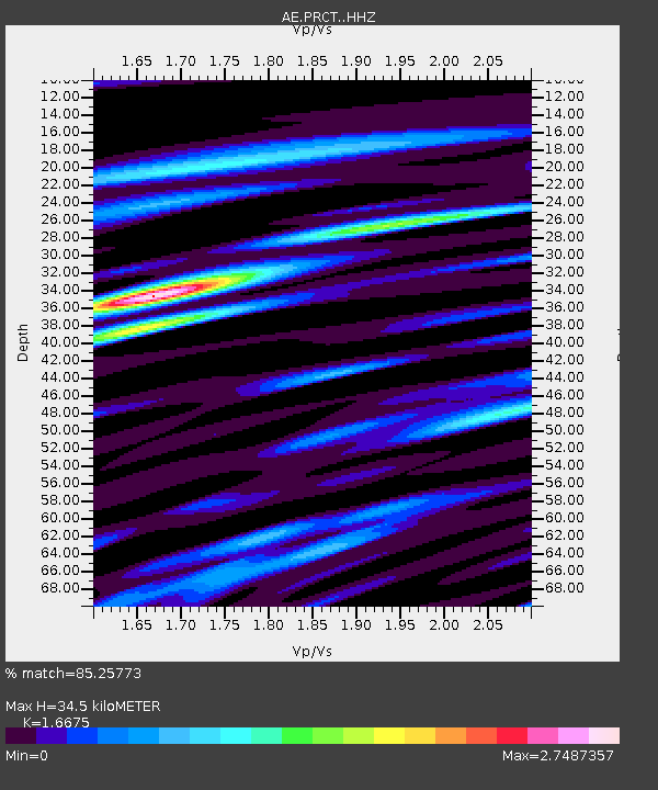
| Estimated Moho Depth: |
34.5 km |
| Estimated Crust Vp/Vs: |
1.67 |
| Assumed Crust Vp: |
6.276 km/s |
| Estimated Crust Vs: |
3.764 km/s |
| Estimated Crust Poisson's Ratio: |
0.22 |
|
| Radial Match: |
85.25773 % |
| Radial Bump: |
400 |
| Transverse Match: |
60.210052 % |
| Transverse Bump: |
400 |
| SOD ConfigId: |
29823551 |
| Insert Time: |
2023-02-03 11:24:55.086 +0000 |
| GWidth: |
2.5 |
| Max Bumps: |
400 |
| Tol: |
0.001 |
|

Signal To Noise
| Channel | StoN | STA | LTA |
| AE:PRCT: :HHZ:20230120T11:31:38.109985Z | 8.394839 | 1.7423278E-6 | 2.0754746E-7 |
| AE:PRCT: :HHN:20230120T11:31:38.109985Z | 1.4985697 | 2.8021725E-7 | 1.869898E-7 |
| AE:PRCT: :HHE:20230120T11:31:38.109985Z | 7.5196886 | 1.3153059E-6 | 1.7491494E-7 |
| Arrivals |
| Ps | 3.9 SECOND |
| PpPs | 14 SECOND |
| PsPs/PpSs | 18 SECOND |


