You are here: Home > Network List > XA95 - Missouri to Massachusetts Transect Stations List
> Station MM18 Tyson, Missiouri > Earthquake Result Viewer
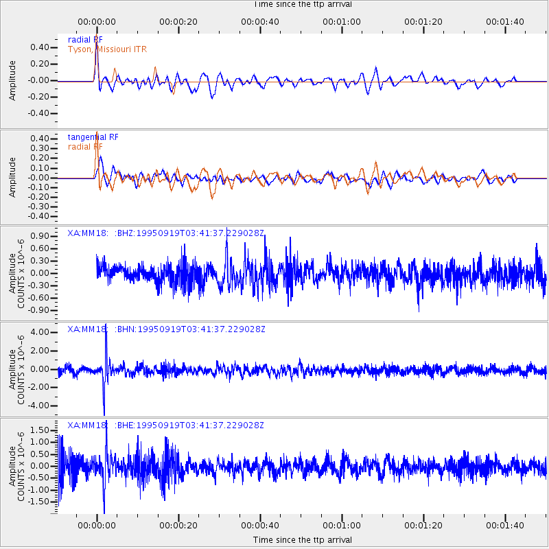
MM18 Tyson, Missiouri - Earthquake Result Viewer
*The percent match for this event was below the threshold and hence no stack was calculated.
| Earthquake location: |
Chile-Bolivia Border Region |
| Earthquake latitude/longitude: |
-21.2/-68.7 |
| Earthquake time(UTC): |
1995/09/19 (262) 03:31:53 GMT |
| Earthquake Depth: |
110 km |
| Earthquake Magnitude: |
5.7 MB, 5.7 UNKNOWN, 5.6 MW |
| Earthquake Catalog/Contributor: |
WHDF/NEIC |
|
| Network: |
XA Missouri to Massachusetts Transect |
| Station: |
MM18 Tyson, Missiouri |
| Lat/Lon: |
38.53 N/90.57 W |
| Elevation: |
186 m |
|
| Distance: |
62.9 deg |
| Az: |
340.872 deg |
| Baz: |
157.059 deg |
| Ray Param: |
$rayparam |
*The percent match for this event was below the threshold and hence was not used in the summary stack. |
|
| Radial Match: |
66.31876 % |
| Radial Bump: |
400 |
| Transverse Match: |
58.492096 % |
| Transverse Bump: |
400 |
| SOD ConfigId: |
4480 |
| Insert Time: |
2010-02-26 17:57:40.947 +0000 |
| GWidth: |
2.5 |
| Max Bumps: |
400 |
| Tol: |
0.001 |
|
Signal To Noise
| Channel | StoN | STA | LTA |
| XA:MM18: :BHN:19950919T03:41:37.229028Z | 4.674146 | 1.5292593E-6 | 3.2717404E-7 |
| XA:MM18: :BHE:19950919T03:41:37.229028Z | 1.3586643 | 5.989483E-7 | 4.4083615E-7 |
| XA:MM18: :BHZ:19950919T03:41:37.229028Z | 1.5866734 | 3.2348234E-7 | 2.0387455E-7 |
| Arrivals |
| Ps | |
| PpPs | |
| PsPs/PpSs | |


