You are here: Home > Network List > CI - Caltech Regional Seismic Network Stations List
> Station MPP McPhearson Peak > Earthquake Result Viewer
MPP McPhearson Peak - Earthquake Result Viewer
*The percent match for this event was below the threshold and hence no stack was calculated.
| Earthquake location: |
Leeward Islands |
| Earthquake latitude/longitude: |
16.2/-62.0 |
| Earthquake time(UTC): |
2023/01/20 (020) 11:23:40 GMT |
| Earthquake Depth: |
165 km |
| Earthquake Magnitude: |
5.8 Mi |
| Earthquake Catalog/Contributor: |
NEIC PDE/pt |
|
| Network: |
CI Caltech Regional Seismic Network |
| Station: |
MPP McPhearson Peak |
| Lat/Lon: |
34.89 N/119.81 W |
| Elevation: |
1739 m |
|
| Distance: |
54.6 deg |
| Az: |
301.437 deg |
| Baz: |
94.433 deg |
| Ray Param: |
$rayparam |
*The percent match for this event was below the threshold and hence was not used in the summary stack. |
|
| Radial Match: |
68.87446 % |
| Radial Bump: |
400 |
| Transverse Match: |
67.279755 % |
| Transverse Bump: |
400 |
| SOD ConfigId: |
29823551 |
| Insert Time: |
2023-02-03 11:36:41.145 +0000 |
| GWidth: |
2.5 |
| Max Bumps: |
400 |
| Tol: |
0.001 |
|
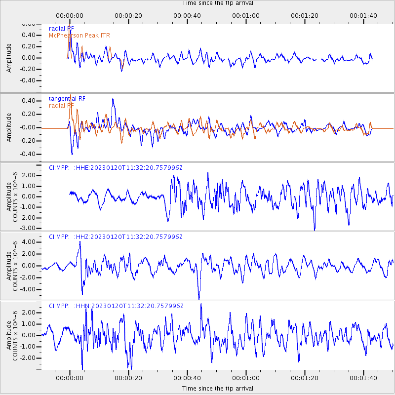
Signal To Noise
| Channel | StoN | STA | LTA |
| CI:MPP: :HHZ:20230120T11:32:20.757996Z | 7.233192 | 2.0112511E-6 | 2.780586E-7 |
| CI:MPP: :HHN:20230120T11:32:20.757996Z | 1.4394841 | 8.150838E-7 | 5.6623327E-7 |
| CI:MPP: :HHE:20230120T11:32:20.757996Z | 2.3945036 | 1.0191266E-6 | 4.2561078E-7 |
| Arrivals |
| Ps | |
| PpPs | |
| PsPs/PpSs | |


