You are here: Home > Network List > XA95 - Missouri to Massachusetts Transect Stations List
> Station MM18 Tyson, Missiouri > Earthquake Result Viewer
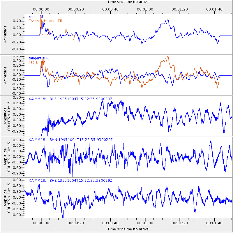
MM18 Tyson, Missiouri - Earthquake Result Viewer
*The percent match for this event was below the threshold and hence no stack was calculated.
| Earthquake location: |
Near Islands, Aleutian Islands |
| Earthquake latitude/longitude: |
52.7/172.5 |
| Earthquake time(UTC): |
1995/10/04 (277) 15:12:34 GMT |
| Earthquake Depth: |
33 km |
| Earthquake Magnitude: |
5.6 MB, 5.4 MS, 5.5 UNKNOWN, 5.9 MW |
| Earthquake Catalog/Contributor: |
WHDF/NEIC |
|
| Network: |
XA Missouri to Massachusetts Transect |
| Station: |
MM18 Tyson, Missiouri |
| Lat/Lon: |
38.53 N/90.57 W |
| Elevation: |
186 m |
|
| Distance: |
64.3 deg |
| Az: |
59.811 deg |
| Baz: |
317.897 deg |
| Ray Param: |
$rayparam |
*The percent match for this event was below the threshold and hence was not used in the summary stack. |
|
| Radial Match: |
28.701803 % |
| Radial Bump: |
400 |
| Transverse Match: |
30.581871 % |
| Transverse Bump: |
400 |
| SOD ConfigId: |
4480 |
| Insert Time: |
2010-02-26 17:57:45.673 +0000 |
| GWidth: |
2.5 |
| Max Bumps: |
400 |
| Tol: |
0.001 |
|
Signal To Noise
| Channel | StoN | STA | LTA |
| XA:MM18: :BHN:19951004T15:22:35.930029Z | 1.3828462 | 3.5455838E-7 | 2.5639753E-7 |
| XA:MM18: :BHE:19951004T15:22:35.930029Z | 1.1353726 | 3.4615437E-7 | 3.0488172E-7 |
| XA:MM18: :BHZ:19951004T15:22:35.930029Z | 2.1327832 | 5.01754E-7 | 2.3525786E-7 |
| Arrivals |
| Ps | |
| PpPs | |
| PsPs/PpSs | |


