You are here: Home > Network List > TA - USArray Transportable Network (new EarthScope stations) Stations List
> Station W27A Bowe Ranch, Endee, NM, USA > Earthquake Result Viewer
W27A Bowe Ranch, Endee, NM, USA - Earthquake Result Viewer
| Earthquake location: |
Near Coast Of Central Chile |
| Earthquake latitude/longitude: |
-34.3/-71.9 |
| Earthquake time(UTC): |
2010/03/11 (070) 14:39:43 GMT |
| Earthquake Depth: |
11 km |
| Earthquake Magnitude: |
6.7 MB, 7.0 MS, 6.9 MW, 6.9 MW |
| Earthquake Catalog/Contributor: |
WHDF/NEIC |
|
| Network: |
TA USArray Transportable Network (new EarthScope stations) |
| Station: |
W27A Bowe Ranch, Endee, NM, USA |
| Lat/Lon: |
35.06 N/103.06 W |
| Elevation: |
1233 m |
|
| Distance: |
74.9 deg |
| Az: |
333.91 deg |
| Baz: |
153.649 deg |
| Ray Param: |
0.05201697 |
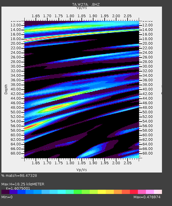
| Estimated Moho Depth: |
18.25 km |
| Estimated Crust Vp/Vs: |
1.61 |
| Assumed Crust Vp: |
6.242 km/s |
| Estimated Crust Vs: |
3.883 km/s |
| Estimated Crust Poisson's Ratio: |
0.18 |
|
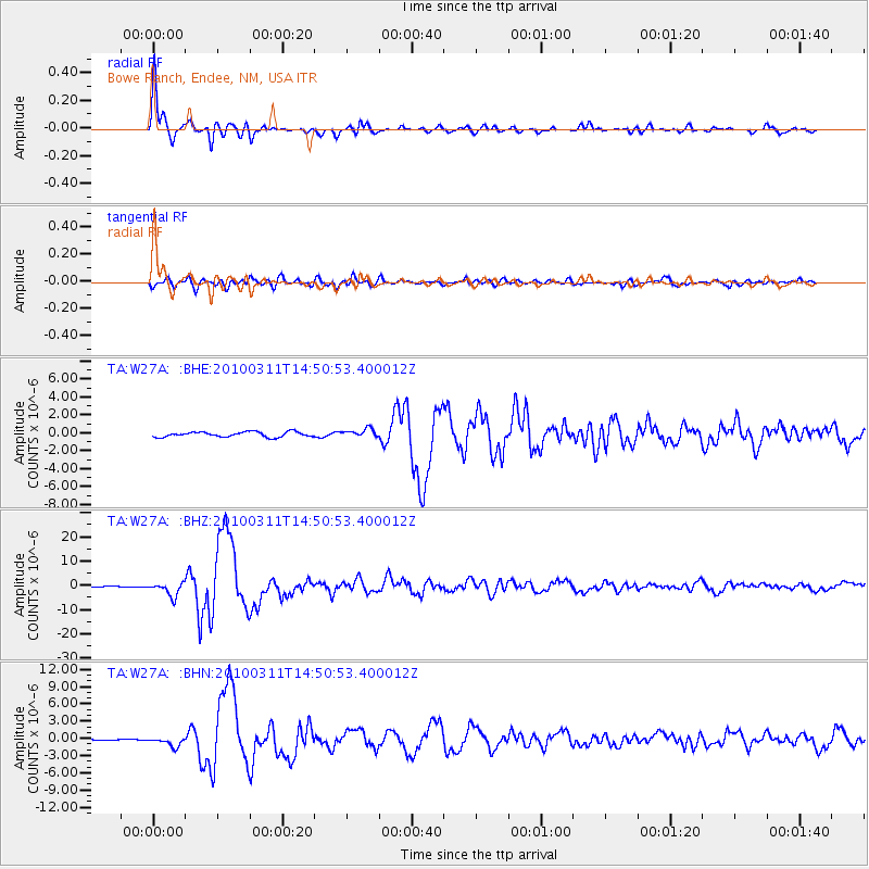
| Radial Match: |
98.47328 % |
| Radial Bump: |
311 |
| Transverse Match: |
89.387535 % |
| Transverse Bump: |
400 |
| SOD ConfigId: |
299721 |
| Insert Time: |
2010-04-26 22:00:41.244 +0000 |
| GWidth: |
2.5 |
| Max Bumps: |
400 |
| Tol: |
0.001 |
|
Signal To Noise
| Channel | StoN | STA | LTA |
| TA:W27A: :BHZ:20100311T14:50:53.400012Z | 13.030462 | 2.816044E-6 | 2.1611234E-7 |
| TA:W27A: :BHN:20100311T14:50:53.400012Z | 5.3021607 | 8.3832225E-7 | 1.5810956E-7 |
| TA:W27A: :BHE:20100311T14:50:53.400012Z | 1.5961727 | 4.4689057E-7 | 2.7997632E-7 |
| Arrivals |
| Ps | 1.8 SECOND |
| PpPs | 7.4 SECOND |
| PsPs/PpSs | 9.2 SECOND |


