You are here: Home > Network List > IW - Intermountain West Stations List
> Station MOOW Moose Ponds, Wyoming, USA > Earthquake Result Viewer
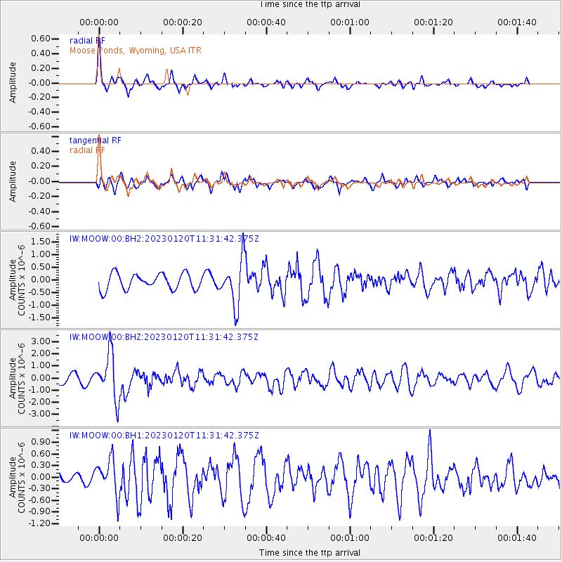
MOOW Moose Ponds, Wyoming, USA - Earthquake Result Viewer
*The percent match for this event was below the threshold and hence no stack was calculated.
| Earthquake location: |
Leeward Islands |
| Earthquake latitude/longitude: |
16.2/-62.0 |
| Earthquake time(UTC): |
2023/01/20 (020) 11:23:40 GMT |
| Earthquake Depth: |
165 km |
| Earthquake Magnitude: |
5.8 Mi |
| Earthquake Catalog/Contributor: |
NEIC PDE/pt |
|
| Network: |
IW Intermountain West |
| Station: |
MOOW Moose Ponds, Wyoming, USA |
| Lat/Lon: |
43.75 N/110.74 W |
| Elevation: |
2128 m |
|
| Distance: |
49.4 deg |
| Az: |
314.167 deg |
| Baz: |
108.044 deg |
| Ray Param: |
$rayparam |
*The percent match for this event was below the threshold and hence was not used in the summary stack. |
|
| Radial Match: |
76.17374 % |
| Radial Bump: |
322 |
| Transverse Match: |
67.80403 % |
| Transverse Bump: |
396 |
| SOD ConfigId: |
29823551 |
| Insert Time: |
2023-02-03 11:44:17.785 +0000 |
| GWidth: |
2.5 |
| Max Bumps: |
400 |
| Tol: |
0.001 |
|
Signal To Noise
| Channel | StoN | STA | LTA |
| IW:MOOW:00:BHZ:20230120T11:31:42.375Z | 6.0706663 | 1.9415972E-6 | 3.1983265E-7 |
| IW:MOOW:00:BH1:20230120T11:31:42.375Z | 1.8659816 | 4.7455777E-7 | 2.5432072E-7 |
| IW:MOOW:00:BH2:20230120T11:31:42.375Z | 2.9926724 | 9.2126044E-7 | 3.0783872E-7 |
| Arrivals |
| Ps | |
| PpPs | |
| PsPs/PpSs | |


