You are here: Home > Network List > LM - Michigan State University Seismic Network Stations List
> Station NHBP Nengshka Wabeno, Nottawaseppi Huron Band of the Potawatomi > Earthquake Result Viewer
NHBP Nengshka Wabeno, Nottawaseppi Huron Band of the Potawatomi - Earthquake Result Viewer
| Earthquake location: |
Leeward Islands |
| Earthquake latitude/longitude: |
16.2/-62.0 |
| Earthquake time(UTC): |
2023/01/20 (020) 11:23:40 GMT |
| Earthquake Depth: |
165 km |
| Earthquake Magnitude: |
5.8 Mi |
| Earthquake Catalog/Contributor: |
NEIC PDE/pt |
|
| Network: |
LM Michigan State University Seismic Network |
| Station: |
NHBP Nengshka Wabeno, Nottawaseppi Huron Band of the Potawatomi |
| Lat/Lon: |
42.10 N/85.27 W |
| Elevation: |
226 m |
|
| Distance: |
32.6 deg |
| Az: |
326.951 deg |
| Baz: |
135.259 deg |
| Ray Param: |
0.07809639 |
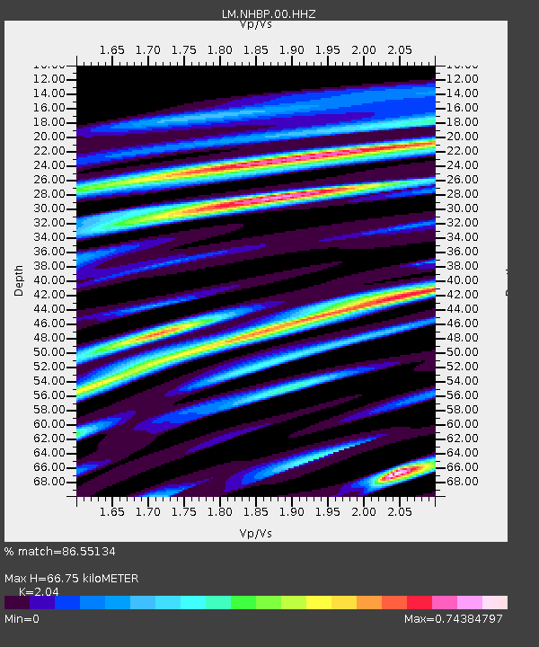
| Estimated Moho Depth: |
66.75 km |
| Estimated Crust Vp/Vs: |
2.04 |
| Assumed Crust Vp: |
6.483 km/s |
| Estimated Crust Vs: |
3.178 km/s |
| Estimated Crust Poisson's Ratio: |
0.34 |
|
| Radial Match: |
86.55134 % |
| Radial Bump: |
380 |
| Transverse Match: |
68.62849 % |
| Transverse Bump: |
400 |
| SOD ConfigId: |
29823551 |
| Insert Time: |
2023-02-03 11:44:31.757 +0000 |
| GWidth: |
2.5 |
| Max Bumps: |
400 |
| Tol: |
0.001 |
|

Signal To Noise
| Channel | StoN | STA | LTA |
| LM:NHBP:00:HHZ:20230120T11:29:25.519989Z | 7.4772844 | 3.4672416E-6 | 4.6370332E-7 |
| LM:NHBP:00:HHN:20230120T11:29:25.519989Z | 3.7678053 | 1.9000486E-6 | 5.0428525E-7 |
| LM:NHBP:00:HHE:20230120T11:29:25.519989Z | 4.7459035 | 1.9966005E-6 | 4.2069976E-7 |
| Arrivals |
| Ps | 11 SECOND |
| PpPs | 29 SECOND |
| PsPs/PpSs | 41 SECOND |


