You are here: Home > Network List > II - Global Seismograph Network (GSN - IRIS/IDA) Stations List
> Station CMLA Cha de Macela, Sao Miguel Island, Azores > Earthquake Result Viewer
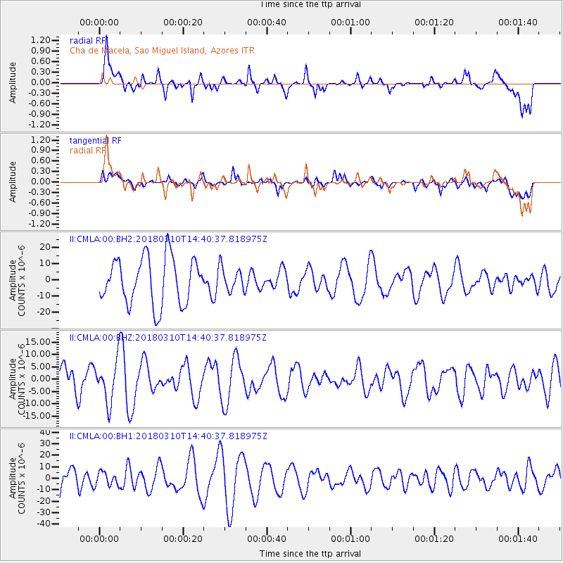
CMLA Cha de Macela, Sao Miguel Island, Azores - Earthquake Result Viewer
*The percent match for this event was below the threshold and hence no stack was calculated.
| Earthquake location: |
South Sandwich Islands Region |
| Earthquake latitude/longitude: |
-56.3/-28.1 |
| Earthquake time(UTC): |
2018/03/10 (069) 14:27:56 GMT |
| Earthquake Depth: |
50 km |
| Earthquake Magnitude: |
5.6 Mww |
| Earthquake Catalog/Contributor: |
NEIC PDE/us |
|
| Network: |
II Global Seismograph Network (GSN - IRIS/IDA) |
| Station: |
CMLA Cha de Macela, Sao Miguel Island, Azores |
| Lat/Lon: |
37.76 N/25.52 W |
| Elevation: |
429 m |
|
| Distance: |
93.7 deg |
| Az: |
2.014 deg |
| Baz: |
181.416 deg |
| Ray Param: |
$rayparam |
*The percent match for this event was below the threshold and hence was not used in the summary stack. |
|
| Radial Match: |
57.572792 % |
| Radial Bump: |
400 |
| Transverse Match: |
36.715954 % |
| Transverse Bump: |
400 |
| SOD ConfigId: |
2973751 |
| Insert Time: |
2018-10-09 09:38:09.797 +0000 |
| GWidth: |
2.5 |
| Max Bumps: |
400 |
| Tol: |
0.001 |
|
Signal To Noise
| Channel | StoN | STA | LTA |
| II:CMLA:00:BHZ:20180310T14:40:37.818975Z | 1.7441727 | 9.046545E-6 | 5.186725E-6 |
| II:CMLA:00:BH1:20180310T14:40:37.818975Z | 0.39317155 | 5.6144713E-6 | 1.4279954E-5 |
| II:CMLA:00:BH2:20180310T14:40:37.818975Z | 0.50092405 | 7.3099322E-6 | 1.4592895E-5 |
| Arrivals |
| Ps | |
| PpPs | |
| PsPs/PpSs | |


