You are here: Home > Network List > N4 - Central and EAstern US Network Stations List
> Station R32B Long Quarter, Great Bend, KS, USA > Earthquake Result Viewer
R32B Long Quarter, Great Bend, KS, USA - Earthquake Result Viewer
| Earthquake location: |
Leeward Islands |
| Earthquake latitude/longitude: |
16.2/-62.0 |
| Earthquake time(UTC): |
2023/01/20 (020) 11:23:40 GMT |
| Earthquake Depth: |
165 km |
| Earthquake Magnitude: |
5.8 Mi |
| Earthquake Catalog/Contributor: |
NEIC PDE/pt |
|
| Network: |
N4 Central and EAstern US Network |
| Station: |
R32B Long Quarter, Great Bend, KS, USA |
| Lat/Lon: |
38.42 N/98.71 W |
| Elevation: |
568 m |
|
| Distance: |
39.0 deg |
| Az: |
311.787 deg |
| Baz: |
114.234 deg |
| Ray Param: |
0.0746175 |
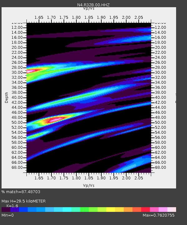
| Estimated Moho Depth: |
29.5 km |
| Estimated Crust Vp/Vs: |
1.60 |
| Assumed Crust Vp: |
6.483 km/s |
| Estimated Crust Vs: |
4.052 km/s |
| Estimated Crust Poisson's Ratio: |
0.18 |
|
| Radial Match: |
87.48703 % |
| Radial Bump: |
286 |
| Transverse Match: |
59.864056 % |
| Transverse Bump: |
400 |
| SOD ConfigId: |
29823551 |
| Insert Time: |
2023-02-03 11:46:13.644 +0000 |
| GWidth: |
2.5 |
| Max Bumps: |
400 |
| Tol: |
0.001 |
|

Signal To Noise
| Channel | StoN | STA | LTA |
| N4:R32B:00:HHZ:20230120T11:30:19.979004Z | 14.86932 | 4.640649E-6 | 3.1209558E-7 |
| N4:R32B:00:HH1:20230120T11:30:19.979004Z | 5.382783 | 1.3420985E-6 | 2.4933172E-7 |
| N4:R32B:00:HH2:20230120T11:30:19.979004Z | 7.7026544 | 3.6072313E-6 | 4.6831016E-7 |
| Arrivals |
| Ps | 3.0 SECOND |
| PpPs | 11 SECOND |
| PsPs/PpSs | 14 SECOND |


