You are here: Home > Network List > N4 - Central and EAstern US Network Stations List
> Station WHTX Lake Whitney, Meridian, TX, USA > Earthquake Result Viewer
WHTX Lake Whitney, Meridian, TX, USA - Earthquake Result Viewer
| Earthquake location: |
Leeward Islands |
| Earthquake latitude/longitude: |
16.2/-62.0 |
| Earthquake time(UTC): |
2023/01/20 (020) 11:23:40 GMT |
| Earthquake Depth: |
165 km |
| Earthquake Magnitude: |
5.8 Mi |
| Earthquake Catalog/Contributor: |
NEIC PDE/pt |
|
| Network: |
N4 Central and EAstern US Network |
| Station: |
WHTX Lake Whitney, Meridian, TX, USA |
| Lat/Lon: |
31.99 N/97.46 W |
| Elevation: |
190 m |
|
| Distance: |
35.8 deg |
| Az: |
302.514 deg |
| Baz: |
107.579 deg |
| Ray Param: |
0.076491915 |
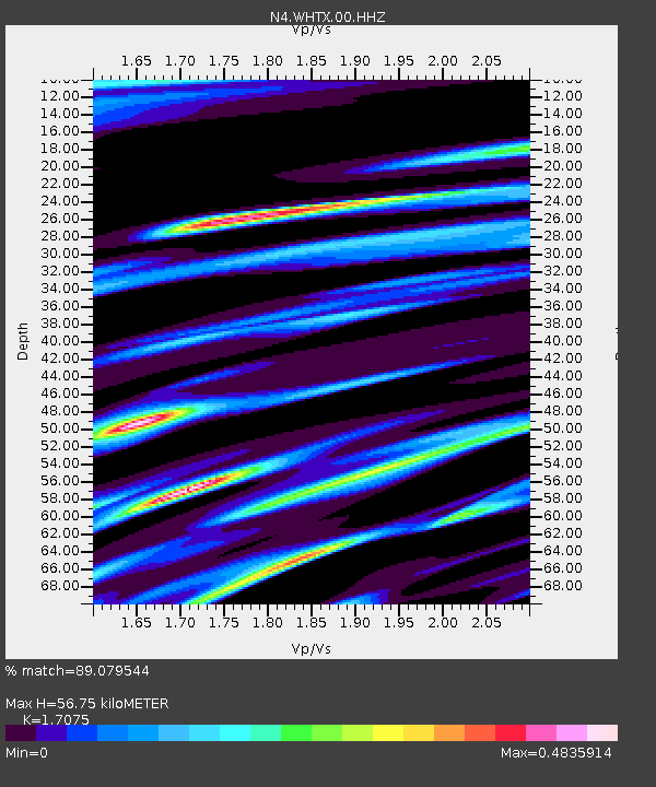
| Estimated Moho Depth: |
56.75 km |
| Estimated Crust Vp/Vs: |
1.71 |
| Assumed Crust Vp: |
6.347 km/s |
| Estimated Crust Vs: |
3.717 km/s |
| Estimated Crust Poisson's Ratio: |
0.24 |
|
| Radial Match: |
89.079544 % |
| Radial Bump: |
240 |
| Transverse Match: |
55.316578 % |
| Transverse Bump: |
341 |
| SOD ConfigId: |
29823551 |
| Insert Time: |
2023-02-03 11:46:32.257 +0000 |
| GWidth: |
2.5 |
| Max Bumps: |
400 |
| Tol: |
0.001 |
|

Signal To Noise
| Channel | StoN | STA | LTA |
| N4:WHTX:00:HHZ:20230120T11:29:52.619995Z | 17.223381 | 3.9012257E-6 | 2.2650752E-7 |
| N4:WHTX:00:HH1:20230120T11:29:52.619995Z | 2.7675042 | 6.9803895E-7 | 2.522269E-7 |
| N4:WHTX:00:HH2:20230120T11:29:52.619995Z | 7.4784117 | 2.2749368E-6 | 3.0420054E-7 |
| Arrivals |
| Ps | 6.8 SECOND |
| PpPs | 22 SECOND |
| PsPs/PpSs | 29 SECOND |


