You are here: Home > Network List > N4 - Central and EAstern US Network Stations List
> Station Y45B Coffeeville, MS, USA > Earthquake Result Viewer
Y45B Coffeeville, MS, USA - Earthquake Result Viewer
| Earthquake location: |
Leeward Islands |
| Earthquake latitude/longitude: |
16.2/-62.0 |
| Earthquake time(UTC): |
2023/01/20 (020) 11:23:40 GMT |
| Earthquake Depth: |
165 km |
| Earthquake Magnitude: |
5.8 Mi |
| Earthquake Catalog/Contributor: |
NEIC PDE/pt |
|
| Network: |
N4 Central and EAstern US Network |
| Station: |
Y45B Coffeeville, MS, USA |
| Lat/Lon: |
33.87 N/89.54 W |
| Elevation: |
101 m |
|
| Distance: |
30.4 deg |
| Az: |
310.439 deg |
| Baz: |
118.518 deg |
| Ray Param: |
0.07905479 |
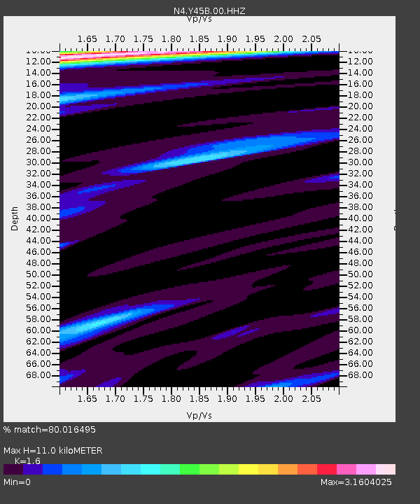
| Estimated Moho Depth: |
11.0 km |
| Estimated Crust Vp/Vs: |
1.60 |
| Assumed Crust Vp: |
6.201 km/s |
| Estimated Crust Vs: |
3.876 km/s |
| Estimated Crust Poisson's Ratio: |
0.18 |
|
| Radial Match: |
80.016495 % |
| Radial Bump: |
344 |
| Transverse Match: |
71.685936 % |
| Transverse Bump: |
390 |
| SOD ConfigId: |
29823551 |
| Insert Time: |
2023-02-03 11:46:35.710 +0000 |
| GWidth: |
2.5 |
| Max Bumps: |
400 |
| Tol: |
0.001 |
|

Signal To Noise
| Channel | StoN | STA | LTA |
| N4:Y45B:00:HHZ:20230120T11:29:05.908997Z | 8.902403 | 7.0837364E-6 | 7.9571066E-7 |
| N4:Y45B:00:HH1:20230120T11:29:05.908997Z | 3.0808296 | 2.3874122E-6 | 7.749251E-7 |
| N4:Y45B:00:HH2:20230120T11:29:05.908997Z | 1.1767339 | 1.3836968E-6 | 1.1758792E-6 |
| Arrivals |
| Ps | 1.2 SECOND |
| PpPs | 4.2 SECOND |
| PsPs/PpSs | 5.4 SECOND |


