You are here: Home > Network List > US - United States National Seismic Network Stations List
> Station MSO Missoula, Montana, USA > Earthquake Result Viewer
MSO Missoula, Montana, USA - Earthquake Result Viewer
*The percent match for this event was below the threshold and hence no stack was calculated.
| Earthquake location: |
North Of Ascension Island |
| Earthquake latitude/longitude: |
-1.4/-15.2 |
| Earthquake time(UTC): |
2018/03/10 (069) 21:45:36 GMT |
| Earthquake Depth: |
10 km |
| Earthquake Magnitude: |
5.9 Mww |
| Earthquake Catalog/Contributor: |
NEIC PDE/us |
|
| Network: |
US United States National Seismic Network |
| Station: |
MSO Missoula, Montana, USA |
| Lat/Lon: |
46.83 N/113.94 W |
| Elevation: |
1264 m |
|
| Distance: |
97.0 deg |
| Az: |
316.861 deg |
| Baz: |
84.594 deg |
| Ray Param: |
$rayparam |
*The percent match for this event was below the threshold and hence was not used in the summary stack. |
|
| Radial Match: |
56.06395 % |
| Radial Bump: |
400 |
| Transverse Match: |
54.062096 % |
| Transverse Bump: |
400 |
| SOD ConfigId: |
2973751 |
| Insert Time: |
2018-10-09 09:42:55.078 +0000 |
| GWidth: |
2.5 |
| Max Bumps: |
400 |
| Tol: |
0.001 |
|
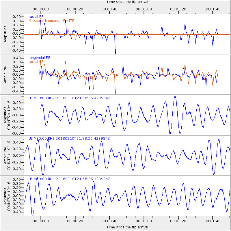
Signal To Noise
| Channel | StoN | STA | LTA |
| US:MSO:00:BHZ:20180310T21:58:36.423984Z | 2.9742815 | 3.889761E-7 | 1.3077985E-7 |
| US:MSO:00:BH1:20180310T21:58:36.423984Z | 1.4143927 | 2.1856285E-7 | 1.545277E-7 |
| US:MSO:00:BH2:20180310T21:58:36.423984Z | 0.41657963 | 7.2863074E-8 | 1.7490791E-7 |
| Arrivals |
| Ps | |
| PpPs | |
| PsPs/PpSs | |


