You are here: Home > Network List > XA95 - Missouri to Massachusetts Transect Stations List
> Station MM18 Tyson, Missiouri > Earthquake Result Viewer
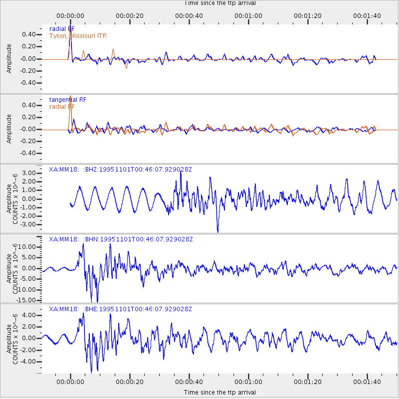
MM18 Tyson, Missiouri - Earthquake Result Viewer
*The percent match for this event was below the threshold and hence no stack was calculated.
| Earthquake location: |
Near Coast Of Central Chile |
| Earthquake latitude/longitude: |
-29.0/-71.5 |
| Earthquake time(UTC): |
1995/11/01 (305) 00:35:32 GMT |
| Earthquake Depth: |
20 km |
| Earthquake Magnitude: |
6.3 MB, 6.4 MS, 6.3 UNKNOWN, 6.7 MW |
| Earthquake Catalog/Contributor: |
WHDF/NEIC |
|
| Network: |
XA Missouri to Massachusetts Transect |
| Station: |
MM18 Tyson, Missiouri |
| Lat/Lon: |
38.53 N/90.57 W |
| Elevation: |
186 m |
|
| Distance: |
69.5 deg |
| Az: |
344.122 deg |
| Baz: |
162.2 deg |
| Ray Param: |
$rayparam |
*The percent match for this event was below the threshold and hence was not used in the summary stack. |
|
| Radial Match: |
72.365295 % |
| Radial Bump: |
323 |
| Transverse Match: |
67.53119 % |
| Transverse Bump: |
400 |
| SOD ConfigId: |
4480 |
| Insert Time: |
2010-02-26 17:57:49.644 +0000 |
| GWidth: |
2.5 |
| Max Bumps: |
400 |
| Tol: |
0.001 |
|
Signal To Noise
| Channel | StoN | STA | LTA |
| XA:MM18: :BHN:19951101T00:46:07.929028Z | 7.345189 | 4.616104E-6 | 6.2845277E-7 |
| XA:MM18: :BHE:19951101T00:46:07.929028Z | 2.8698046 | 2.0065784E-6 | 6.992039E-7 |
| XA:MM18: :BHZ:19951101T00:46:07.929028Z | 0.91932994 | 8.5255607E-7 | 9.273668E-7 |
| Arrivals |
| Ps | |
| PpPs | |
| PsPs/PpSs | |


