You are here: Home > Network List > NW - Northwestern University Seismic Network Stations List
> Station L44A Ryerson Woods, Lake Cnty Forest Preserve, IL, USA > Earthquake Result Viewer
L44A Ryerson Woods, Lake Cnty Forest Preserve, IL, USA - Earthquake Result Viewer
| Earthquake location: |
Leeward Islands |
| Earthquake latitude/longitude: |
16.2/-62.0 |
| Earthquake time(UTC): |
2023/01/20 (020) 11:23:40 GMT |
| Earthquake Depth: |
165 km |
| Earthquake Magnitude: |
5.8 Mi |
| Earthquake Catalog/Contributor: |
NEIC PDE/pt |
|
| Network: |
NW Northwestern University Seismic Network |
| Station: |
L44A Ryerson Woods, Lake Cnty Forest Preserve, IL, USA |
| Lat/Lon: |
42.18 N/87.91 W |
| Elevation: |
202 m |
|
| Distance: |
34.1 deg |
| Az: |
324.598 deg |
| Baz: |
131.524 deg |
| Ray Param: |
0.07736086 |
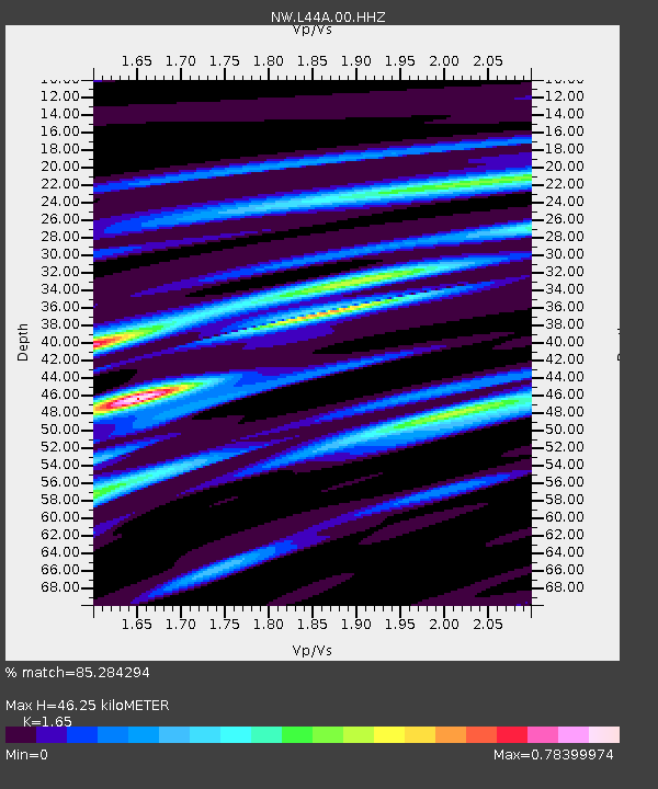
| Estimated Moho Depth: |
46.25 km |
| Estimated Crust Vp/Vs: |
1.65 |
| Assumed Crust Vp: |
6.483 km/s |
| Estimated Crust Vs: |
3.929 km/s |
| Estimated Crust Poisson's Ratio: |
0.21 |
|
| Radial Match: |
85.284294 % |
| Radial Bump: |
306 |
| Transverse Match: |
58.132755 % |
| Transverse Bump: |
400 |
| SOD ConfigId: |
29823551 |
| Insert Time: |
2023-02-03 11:48:22.602 +0000 |
| GWidth: |
2.5 |
| Max Bumps: |
400 |
| Tol: |
0.001 |
|

Signal To Noise
| Channel | StoN | STA | LTA |
| NW:L44A:00:HHZ:20230120T11:29:38.339996Z | 13.758677 | 8.0986465E-6 | 5.88621E-7 |
| NW:L44A:00:HH1:20230120T11:29:38.339996Z | 7.130473 | 3.995722E-6 | 5.6037265E-7 |
| NW:L44A:00:HH2:20230120T11:29:38.339996Z | 6.034561 | 4.2050106E-6 | 6.9682125E-7 |
| Arrivals |
| Ps | 5.0 SECOND |
| PpPs | 17 SECOND |
| PsPs/PpSs | 22 SECOND |


