You are here: Home > Network List > NX - Nanometrics Research Network Stations List
> Station WTX28 Z > Earthquake Result Viewer
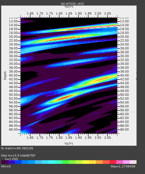
WTX28 Z - Earthquake Result Viewer
| Earthquake location: |
Leeward Islands |
| Earthquake latitude/longitude: |
16.2/-62.0 |
| Earthquake time(UTC): |
2023/01/20 (020) 11:23:40 GMT |
| Earthquake Depth: |
165 km |
| Earthquake Magnitude: |
5.8 Mi |
| Earthquake Catalog/Contributor: |
NEIC PDE/pt |
|
| Network: |
NX Nanometrics Research Network |
| Station: |
WTX28 Z |
| Lat/Lon: |
32.88 N/103.38 W |
| Elevation: |
1173 m |
|
| Distance: |
40.8 deg |
| Az: |
301.704 deg |
| Baz: |
103.78 deg |
| Ray Param: |
0.07354606 |
| Estimated Moho Depth: |
14.5 km |
| Estimated Crust Vp/Vs: |
2.06 |
| Assumed Crust Vp: |
6.129 km/s |
| Estimated Crust Vs: |
2.982 km/s |
| Estimated Crust Poisson's Ratio: |
0.34 |
|
| Radial Match: |
89.380165 % |
| Radial Bump: |
300 |
| Transverse Match: |
56.20554 % |
| Transverse Bump: |
400 |
| SOD ConfigId: |
29823551 |
| Insert Time: |
2023-02-03 11:48:31.062 +0000 |
| GWidth: |
2.5 |
| Max Bumps: |
400 |
| Tol: |
0.001 |
|

Signal To Noise
| Channel | StoN | STA | LTA |
| NX:WTX28: :HHZ:20230120T11:30:34.785004Z | 9.044212 | 2.4829685E-6 | 2.7453672E-7 |
| NX:WTX28: :HHN:20230120T11:30:34.785004Z | 1.0844368 | 3.999696E-7 | 3.6882705E-7 |
| NX:WTX28: :HHE:20230120T11:30:34.785004Z | 5.1804 | 1.9115141E-6 | 3.689897E-7 |
| Arrivals |
| Ps | 2.6 SECOND |
| PpPs | 6.9 SECOND |
| PsPs/PpSs | 9.5 SECOND |


