You are here: Home > Network List > O2 - Oklahoma Consolidated Temporary Seismic Networks Stations List
> Station FW01 Cuddy Creek, Oklahoma, USA > Earthquake Result Viewer
FW01 Cuddy Creek, Oklahoma, USA - Earthquake Result Viewer
| Earthquake location: |
Leeward Islands |
| Earthquake latitude/longitude: |
16.2/-62.0 |
| Earthquake time(UTC): |
2023/01/20 (020) 11:23:40 GMT |
| Earthquake Depth: |
165 km |
| Earthquake Magnitude: |
5.8 Mi |
| Earthquake Catalog/Contributor: |
NEIC PDE/pt |
|
| Network: |
O2 Oklahoma Consolidated Temporary Seismic Networks |
| Station: |
FW01 Cuddy Creek, Oklahoma, USA |
| Lat/Lon: |
36.49 N/98.94 W |
| Elevation: |
431 m |
|
| Distance: |
38.4 deg |
| Az: |
308.841 deg |
| Baz: |
111.796 deg |
| Ray Param: |
0.07497097 |
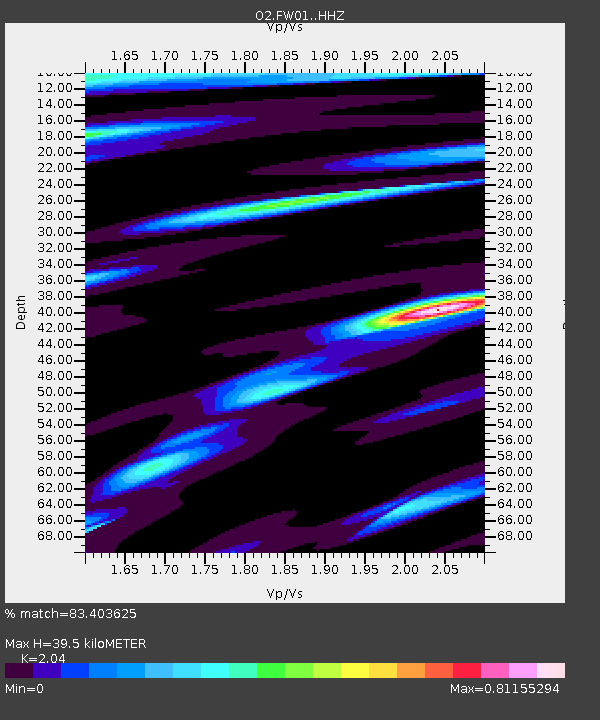
| Estimated Moho Depth: |
39.5 km |
| Estimated Crust Vp/Vs: |
2.04 |
| Assumed Crust Vp: |
6.426 km/s |
| Estimated Crust Vs: |
3.15 km/s |
| Estimated Crust Poisson's Ratio: |
0.34 |
|
| Radial Match: |
83.403625 % |
| Radial Bump: |
265 |
| Transverse Match: |
45.920746 % |
| Transverse Bump: |
386 |
| SOD ConfigId: |
29823551 |
| Insert Time: |
2023-02-03 11:48:55.066 +0000 |
| GWidth: |
2.5 |
| Max Bumps: |
400 |
| Tol: |
0.001 |
|

Signal To Noise
| Channel | StoN | STA | LTA |
| O2:FW01: :HHZ:20230120T11:30:15.125Z | 10.898192 | 7.0143838E-6 | 6.436282E-7 |
| O2:FW01: :HHN:20230120T11:30:15.125Z | 3.7698615 | 1.4269086E-6 | 3.7850424E-7 |
| O2:FW01: :HHE:20230120T11:30:15.125Z | 5.3595314 | 4.047929E-6 | 7.552767E-7 |
| Arrivals |
| Ps | 6.8 SECOND |
| PpPs | 18 SECOND |
| PsPs/PpSs | 24 SECOND |


