You are here: Home > Network List > XA95 - Missouri to Massachusetts Transect Stations List
> Station MM18 Tyson, Missiouri > Earthquake Result Viewer
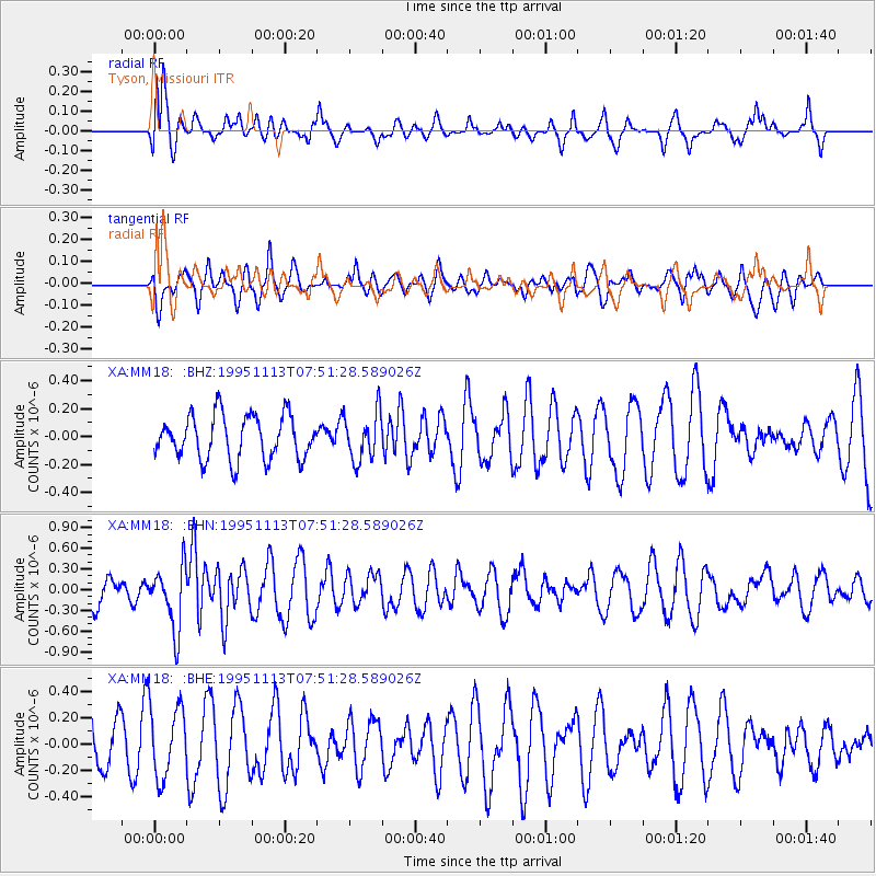
MM18 Tyson, Missiouri - Earthquake Result Viewer
*The percent match for this event was below the threshold and hence no stack was calculated.
| Earthquake location: |
Tonga Islands |
| Earthquake latitude/longitude: |
-15.1/-173.5 |
| Earthquake time(UTC): |
1995/11/13 (317) 07:38:45 GMT |
| Earthquake Depth: |
33 km |
| Earthquake Magnitude: |
5.7 MB, 5.9 MS, 6.1 UNKNOWN, 6.0 MW |
| Earthquake Catalog/Contributor: |
WHDF/NEIC |
|
| Network: |
XA Missouri to Massachusetts Transect |
| Station: |
MM18 Tyson, Missiouri |
| Lat/Lon: |
38.53 N/90.57 W |
| Elevation: |
186 m |
|
| Distance: |
93.9 deg |
| Az: |
51.274 deg |
| Baz: |
253.895 deg |
| Ray Param: |
$rayparam |
*The percent match for this event was below the threshold and hence was not used in the summary stack. |
|
| Radial Match: |
60.535454 % |
| Radial Bump: |
400 |
| Transverse Match: |
34.722675 % |
| Transverse Bump: |
400 |
| SOD ConfigId: |
4480 |
| Insert Time: |
2010-02-26 17:57:51.070 +0000 |
| GWidth: |
2.5 |
| Max Bumps: |
400 |
| Tol: |
0.001 |
|
Signal To Noise
| Channel | StoN | STA | LTA |
| XA:MM18: :BHN:19951113T07:51:28.589026Z | 1.8138711 | 4.5618262E-7 | 2.5149672E-7 |
| XA:MM18: :BHE:19951113T07:51:28.589026Z | 0.98713106 | 2.719111E-7 | 2.7545593E-7 |
| XA:MM18: :BHZ:19951113T07:51:28.589026Z | 1.0980102 | 1.7060815E-7 | 1.5537938E-7 |
| Arrivals |
| Ps | |
| PpPs | |
| PsPs/PpSs | |


