You are here: Home > Network List > O2 - Oklahoma Consolidated Temporary Seismic Networks Stations List
> Station SAND Sand Springs, Oklahoma, USA > Earthquake Result Viewer
SAND Sand Springs, Oklahoma, USA - Earthquake Result Viewer
| Earthquake location: |
Leeward Islands |
| Earthquake latitude/longitude: |
16.2/-62.0 |
| Earthquake time(UTC): |
2023/01/20 (020) 11:23:40 GMT |
| Earthquake Depth: |
165 km |
| Earthquake Magnitude: |
5.8 Mi |
| Earthquake Catalog/Contributor: |
NEIC PDE/pt |
|
| Network: |
O2 Oklahoma Consolidated Temporary Seismic Networks |
| Station: |
SAND Sand Springs, Oklahoma, USA |
| Lat/Lon: |
36.06 N/96.25 W |
| Elevation: |
261 m |
|
| Distance: |
36.3 deg |
| Az: |
309.572 deg |
| Baz: |
113.963 deg |
| Ray Param: |
0.07620659 |
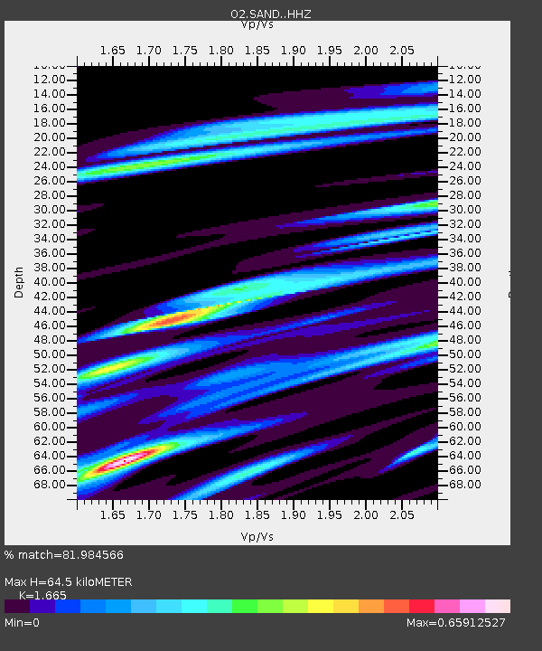
| Estimated Moho Depth: |
64.5 km |
| Estimated Crust Vp/Vs: |
1.66 |
| Assumed Crust Vp: |
6.483 km/s |
| Estimated Crust Vs: |
3.893 km/s |
| Estimated Crust Poisson's Ratio: |
0.22 |
|
| Radial Match: |
81.984566 % |
| Radial Bump: |
287 |
| Transverse Match: |
61.093502 % |
| Transverse Bump: |
400 |
| SOD ConfigId: |
29823551 |
| Insert Time: |
2023-02-03 11:49:40.692 +0000 |
| GWidth: |
2.5 |
| Max Bumps: |
400 |
| Tol: |
0.001 |
|

Signal To Noise
| Channel | StoN | STA | LTA |
| O2:SAND: :HHZ:20230120T11:29:56.88501Z | 7.834028 | 5.316263E-6 | 6.7861174E-7 |
| O2:SAND: :HHN:20230120T11:29:56.88501Z | 4.411428 | 1.9649726E-6 | 4.4542782E-7 |
| O2:SAND: :HHE:20230120T11:29:56.88501Z | 5.41567 | 3.4878203E-6 | 6.440238E-7 |
| Arrivals |
| Ps | 7.2 SECOND |
| PpPs | 24 SECOND |
| PsPs/PpSs | 32 SECOND |


