You are here: Home > Network List > O2 - Oklahoma Consolidated Temporary Seismic Networks Stations List
> Station SHWN Shawnee, Oklahoma, USA > Earthquake Result Viewer
SHWN Shawnee, Oklahoma, USA - Earthquake Result Viewer
| Earthquake location: |
Leeward Islands |
| Earthquake latitude/longitude: |
16.2/-62.0 |
| Earthquake time(UTC): |
2023/01/20 (020) 11:23:40 GMT |
| Earthquake Depth: |
165 km |
| Earthquake Magnitude: |
5.8 Mi |
| Earthquake Catalog/Contributor: |
NEIC PDE/pt |
|
| Network: |
O2 Oklahoma Consolidated Temporary Seismic Networks |
| Station: |
SHWN Shawnee, Oklahoma, USA |
| Lat/Lon: |
35.34 N/97.02 W |
| Elevation: |
320 m |
|
| Distance: |
36.6 deg |
| Az: |
308.051 deg |
| Baz: |
112.29 deg |
| Ray Param: |
0.07603462 |
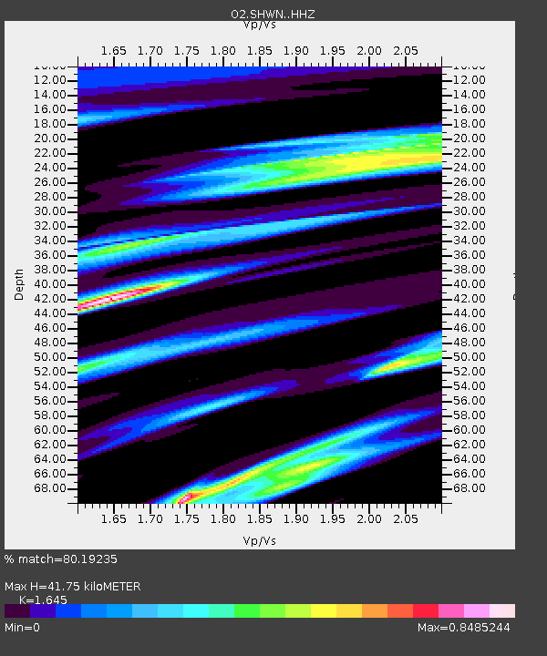
| Estimated Moho Depth: |
41.75 km |
| Estimated Crust Vp/Vs: |
1.64 |
| Assumed Crust Vp: |
6.426 km/s |
| Estimated Crust Vs: |
3.906 km/s |
| Estimated Crust Poisson's Ratio: |
0.21 |
|
| Radial Match: |
80.19235 % |
| Radial Bump: |
265 |
| Transverse Match: |
56.93259 % |
| Transverse Bump: |
293 |
| SOD ConfigId: |
29823551 |
| Insert Time: |
2023-02-03 11:50:08.177 +0000 |
| GWidth: |
2.5 |
| Max Bumps: |
400 |
| Tol: |
0.001 |
|

Signal To Noise
| Channel | StoN | STA | LTA |
| O2:SHWN: :HHZ:20230120T11:29:59.410004Z | 8.617449 | 4.7274407E-6 | 5.485894E-7 |
| O2:SHWN: :HHN:20230120T11:29:59.410004Z | 4.329865 | 1.9647869E-6 | 4.5377558E-7 |
| O2:SHWN: :HHE:20230120T11:29:59.410004Z | 4.332969 | 2.3889513E-6 | 5.513428E-7 |
| Arrivals |
| Ps | 4.5 SECOND |
| PpPs | 16 SECOND |
| PsPs/PpSs | 20 SECOND |


