You are here: Home > Network List > XA95 - Missouri to Massachusetts Transect Stations List
> Station MM18 Tyson, Missiouri > Earthquake Result Viewer
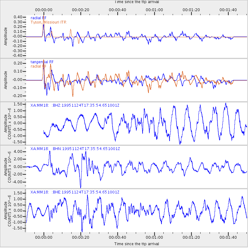
MM18 Tyson, Missiouri - Earthquake Result Viewer
*The percent match for this event was below the threshold and hence no stack was calculated.
| Earthquake location: |
Kuril Islands |
| Earthquake latitude/longitude: |
44.5/149.1 |
| Earthquake time(UTC): |
1995/11/24 (328) 17:24:12 GMT |
| Earthquake Depth: |
33 km |
| Earthquake Magnitude: |
6.1 MB, 6.3 MS, 6.1 UNKNOWN, 6.6 MW |
| Earthquake Catalog/Contributor: |
WHDF/NEIC |
|
| Network: |
XA Missouri to Massachusetts Transect |
| Station: |
MM18 Tyson, Missiouri |
| Lat/Lon: |
38.53 N/90.57 W |
| Elevation: |
186 m |
|
| Distance: |
81.4 deg |
| Az: |
43.211 deg |
| Baz: |
321.373 deg |
| Ray Param: |
$rayparam |
*The percent match for this event was below the threshold and hence was not used in the summary stack. |
|
| Radial Match: |
59.056442 % |
| Radial Bump: |
400 |
| Transverse Match: |
65.71173 % |
| Transverse Bump: |
400 |
| SOD ConfigId: |
4480 |
| Insert Time: |
2010-02-26 17:57:51.772 +0000 |
| GWidth: |
2.5 |
| Max Bumps: |
400 |
| Tol: |
0.001 |
|
Signal To Noise
| Channel | StoN | STA | LTA |
| XA:MM18: :BHN:19951124T17:35:54.651001Z | 3.530237 | 1.4864995E-6 | 4.2107638E-7 |
| XA:MM18: :BHE:19951124T17:35:54.651001Z | 0.63965183 | 3.633489E-7 | 5.680417E-7 |
| XA:MM18: :BHZ:19951124T17:35:54.651001Z | 0.77617884 | 3.5584034E-7 | 4.5845147E-7 |
| Arrivals |
| Ps | |
| PpPs | |
| PsPs/PpSs | |


