You are here: Home > Network List > OK - Oklahoma Seismic Network Stations List
> Station W35A Tecumseh, Oklahoma, USA > Earthquake Result Viewer
W35A Tecumseh, Oklahoma, USA - Earthquake Result Viewer
| Earthquake location: |
Leeward Islands |
| Earthquake latitude/longitude: |
16.2/-62.0 |
| Earthquake time(UTC): |
2023/01/20 (020) 11:23:40 GMT |
| Earthquake Depth: |
165 km |
| Earthquake Magnitude: |
5.8 Mi |
| Earthquake Catalog/Contributor: |
NEIC PDE/pt |
|
| Network: |
OK Oklahoma Seismic Network |
| Station: |
W35A Tecumseh, Oklahoma, USA |
| Lat/Lon: |
35.15 N/96.87 W |
| Elevation: |
322 m |
|
| Distance: |
36.4 deg |
| Az: |
307.832 deg |
| Baz: |
112.199 deg |
| Ray Param: |
0.07614014 |
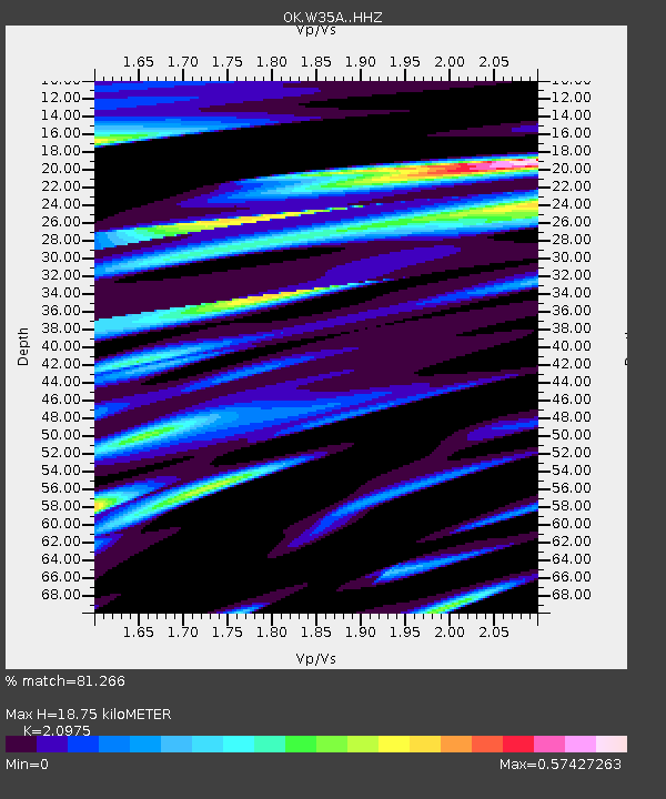
| Estimated Moho Depth: |
18.75 km |
| Estimated Crust Vp/Vs: |
2.10 |
| Assumed Crust Vp: |
6.426 km/s |
| Estimated Crust Vs: |
3.064 km/s |
| Estimated Crust Poisson's Ratio: |
0.35 |
|
| Radial Match: |
81.266 % |
| Radial Bump: |
275 |
| Transverse Match: |
43.872875 % |
| Transverse Bump: |
277 |
| SOD ConfigId: |
29823551 |
| Insert Time: |
2023-02-03 11:50:59.505 +0000 |
| GWidth: |
2.5 |
| Max Bumps: |
400 |
| Tol: |
0.001 |
|

Signal To Noise
| Channel | StoN | STA | LTA |
| OK:W35A: :HHZ:20230120T11:29:57.855011Z | 18.814104 | 3.7156517E-6 | 1.9749288E-7 |
| OK:W35A: :HHN:20230120T11:29:57.855011Z | 2.2859967 | 1.1673977E-6 | 5.1067343E-7 |
| OK:W35A: :HHE:20230120T11:29:57.855011Z | 4.697887 | 1.8871488E-6 | 4.0170158E-7 |
| Arrivals |
| Ps | 3.4 SECOND |
| PpPs | 8.5 SECOND |
| PsPs/PpSs | 12 SECOND |


